It has been a long while since I updated my kampong blog!
Perhaps my memories are fading with age, and all that I can remember has been said?
But once in a while some lucid snaps and trifles still pop up. Here’s one…
This is a photo from the records of NAS (Nat’l Archives Singapore) taken from the summit of Bukit Batok (hill) looking south. Stated as being shot in 1960, so this would be before the RTS TV transmission tower was built.
 |
View from summit of Bukit Batok (hill) looking south. 1960. Photo credit NAS
Click on picture for enlarged detailed view. |
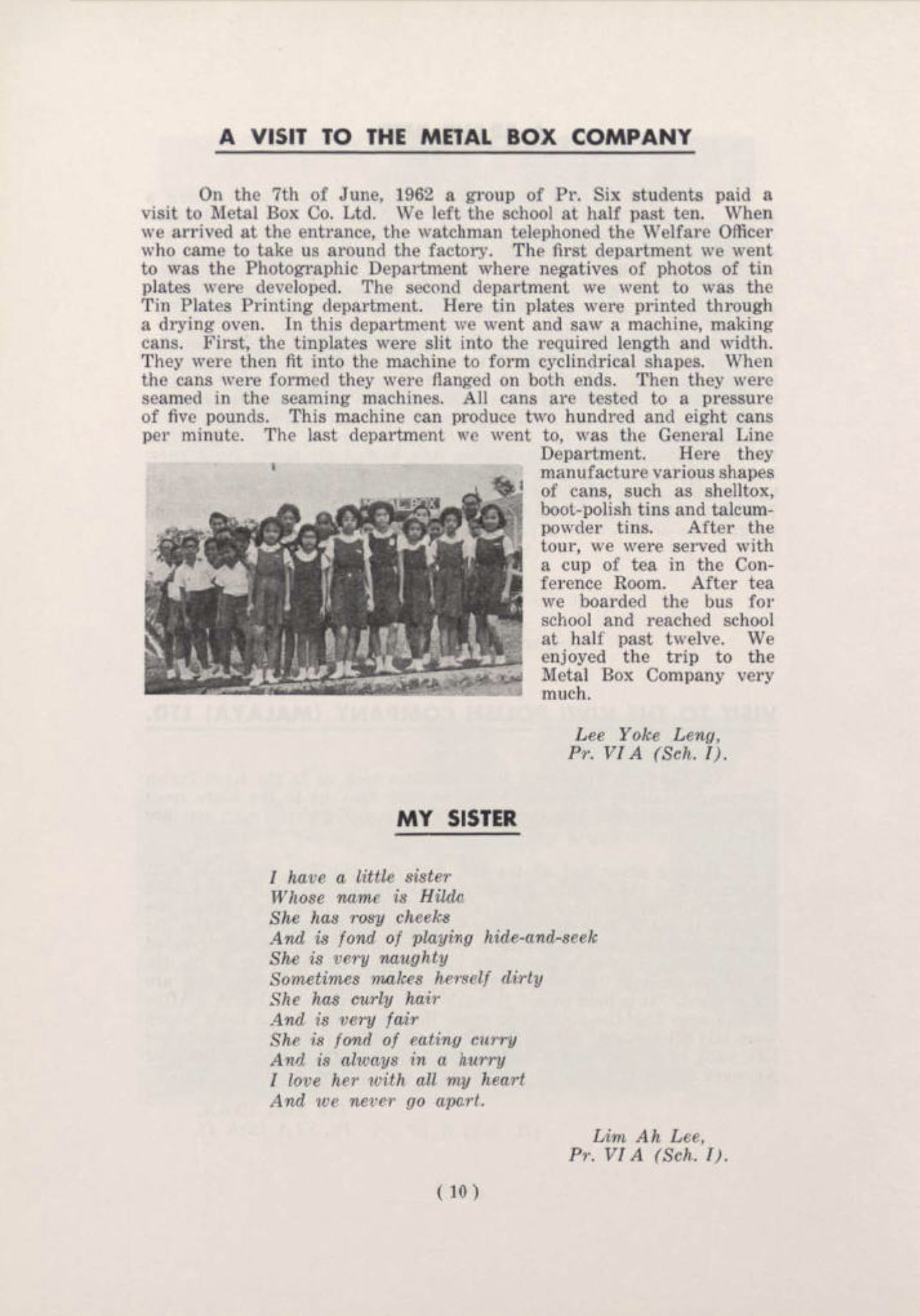
The long white buildings.
Prominent in this picture is the row of buildings in the middle right.
These were the then newly built (1959) schools called Bukit Batok East Primary School and Bukit Batok West Primary School. These buildings are still standing there today!
Due to falling enrolment over the years, these two schools were later merged into one, and eventually moved to a new location at Toh Tuck. Today, the school is known as Bukit Timah Primary School relocated nearby at Lorong Kismis.
Over the years since, the original premises have been leased out mainly as private educational facilities. It was once used as a vocational school, the German International School, as well as a religious organisation creche, and today by the Sparks kindergarten.
Recently, the land was re-zoned for housing development and a new condominium called THE SEN is being built.
The original Hillview EstateOn the left, between the schools and Upper Bukit Timah Road were some plots of land that were once owned by colonial rubber planters before World War II.
On one of these plots was a colonial style plantation house, which the owner named ‘
Hillview Estate’.
During World War II, this colonial house became the Headquarters of the Australian Army Division that was sent from Australia in 1941 to defend Malaya and Singapore.
There is a ‘famous’ PR photo of the Commanding Officer, Maj-Gen Gordon Bennett, taken at Hillview Estate amidst the rubber trees, speaking to war correspondents before the Japanese Invasion of Singapore.
 |
Maj-Gen Gordon Bennett at a press conference with war correspondents in 1942
at the army headquarters at Hillview Estate. |
Beside this historical significance, more importantly, the rubber plantation ‘
Hillview Estate’, was the reference used when the Singapore Rural Board started building new factories on the northern end of Bukit Batok Hill. The 'Hillview' label was used to name the new roads leading into the area,
Hillview Road and
Hillview Avenue.
Thus, beginning from 1947, the region north-west of Bukit Batok hill, more specifically the valley between Bukit Batok and Bukit Gombak, came to be known as "
Hillview".
 |
The junction of Hillview Road with Upper Bukit Timah Road (9-1/2 ms)
The name 'Hillview' was used in reference to the nearby colonial Hillview Estate. |
HILL 145
In the centre of the photo was a huge open patch of vacant land, which on some topographic maps is usually labeled as Hill 145.
From the late 1960s onwards, this hill would be developed for private landed properties and would be first known as Bukit Timah Park, and later as Hoover Park.
The land on the hill was originally bought and owned in majority by Mr. Cheong Chin Nam in 1923 to expand his rubber business.
Unfortunately, Cheong Chin Nam died before his plans for a rubber plantation could be fully achieved. The land was thus held in trust for the Cheong family, who leased it out piecemeal and collected rent as the main source of revenue.
There were no real developments on it due to the poor economic situation at the time.
However, the Cheong family did leave their legacy on the land with roads named after Mr Cheong Chin Nam himself, his wives Yuk Tong and Tham Soong, and for his father Cheong Chun Tin.
Cheong Chin Nam was also instrumental in further developing what would become the early Beauty World Town at Bukit Timah Village. The last remaining row of conserved pre-war buildings along Jalan Jurong Kechil was also built by Cheong Chin Nam.
Today, his legacy continues with his grandson, Dr Cheong Pak Yean, still operating his medical practice from one of the units along that same stretch of conserved pre-war shophouses.
(Trivia: At the far end of this conserved stretch of pre-war houses are the two existing houses that were used as 'comfort houses' for Japanese soldiers during the Japanese occupation)
During World War II, in Feb 1942 when the Japanese Army, advancing from Bukit Panjang to capture Bukit Timah Village, soldiers from their 5th Division cross over this hilltop in their push towards Bukit Timah Village on the other side.
On Japanese war records, this hill was noted as “
Buki Chitaram”; while local records showed that land on the hill was leased to a Mr. Chittabaram who had a banana plantation there.
Though there is no written evidence, I really wonder if that was the reason the internal roads there are all named after various banana species?
Maybe, someone reading this can throw some light on this?
Magnolia Creameries.
In the photo, between Hill 145 and Hillview Estate, there is a tower of some sort.
This was the chimney of the new Cold Storage Magnolia Creameries. It started operations in 1961 to process cow's milk that came from the nearby Singapore Dairy Farm, that was owned by Cold Storage as well.
The factory later expanded, adding a bakery line to produce their Sunshine brand of breads.
You can read more about the Magnolia Creamery here at this link:-
Magnolia CreameriesThe Tank Road-Woodlands Railway.
For those who are unaware of this fact, the first Singapore railway line in 1903 ran from Tank Road at River Valley to Kranji and ended at Woodlands.
From the Woodlands Station, you could take a ferry across to Johore Bahru, as the Causeway was not built until 1922.
This railway track ran from Tank Road, across Cairnhill to Newton, and from Newton it ran parallel to the Rochore Canal (or more commonly called the Bukit Timah Canal today) all the way to north Bukit Timah Village.
From Bukit Timah Village, it followed Jurong Road (Jalan Jurong Kechil today) for a short distance and crossed it at the western slope of Hill 145 (the dotted yellow line in the photo) towards Upper Bukit Timah Road. It then ran alongside with Upper Bukit Timah Road towards Kranji.
The Tank Road-Kranji Railway was removed in 1936 when the new KTM railway line replaced the older Kranji line.
The only remnant of this old Tank Road-Kranji railway line is a side track from Jalan Jurong Kechil (yellow box on map below) that follows the original alignment of the railway line.
The side road is also called Jalan Jurong Kechil.
Hock Soon Warehouse
The Hock Soon Warehouse, sited on the main Upper Bukit Timah, sat on what was once the Hock Soon Rubber Factory beside the Amoy Canning factory (maker of the Green Spot drink of old). The Hock Soon Warehouse was an office/warehouse complex that had several renowned companies located within, including a showroom for Honda Motors on the ground floor.
Today, this site is occupied by the Southhaven II condominium.
1960 vs. 2025Here is the original unedited photo from NAS of the landscape compared to a Google Earth view from a similar angle.