Friday, August 19, 2022

Hillview Avenue was a proposed railway track !

When I was preparing a sketch map for my previous post, I searched for one that would show the hills and relief of the area around Hillview. I found an old 1924 map and used that as an overlay for my sketch map about battles that occurred in the region of Hillview.

Most everyone, I am sure, would not have noticed something on the battle map unless you are into railways or perhaps tried to look for the Rail Corridor which, of course being 1924, would not be on the map. Was there something different about the railway line there?

While doing the sketch map, my mind too got distracted by the railway line and I was thinking that perhaps I could share some trivial information that I knew about the railway line here.

On the battle map, there is a railway line drawn from Bukit Timah Village running towards Bukit Panjang.
This railway line was not the one that is today's Rail Corridor, the NParks project to conserve the former KTM railway corridor as a 'Green Corridor'.
This rail line was the older and original Tank Road-Kranji Railway, or sometimes called the Singapore to Woodlands Railway.

I reproduced the map here and the Tank Road-Kranji Line is marked in RED

(Click on picture for detailed view)


The original Tank Road-Kranji Line that was laid in 1903 ran alongside Bukit Timah Road (from Newton) to Bukit Timah Village. From there, it curved back towards Upper Bukit Timah Road and continued northwards to Bukit Panjang Village, on the western side of the road.

In 1932, the Tank Road-Kranji Line was replaced by the new Keretapi Tanah Melayu (KTM) Railway (marked in BLUE in the map) that started from Tanjong Pagar instead. Now defunct since 2011, this is the current Rail Corridor. 
In this region, the KTM Railway ran along the foothills of Bukit Timah Hill and crossed Upper Bukit Timah Road near Rail Mall, continuing north using the same track-bed as the older Kranji Line all the way to the Johore Causeway.

While this may be something that some of you already know, that there were two separate railways, there's more trivia about this section of the railway that will surprise most of you.

The proposed Hillview Line
When the 1903 Tank Road-Kranji Line was being planned, the original route was proposed on the western side of Bukit Batok (hill). This would be through the valley between Bukit Batok and Bukit Gombak, in the region that would in future become 'Hillview'. The planned route is marked in YELLOW above. 

However, this plan was rejected and the route was redesigned for the railway track to run along the eastern slope of Bukit Batok, running parallel to Upper Bukit Timah Road. 
You can see the abrupt change in the track direction after Bukit Timah Village. This diversion would be at Toh Tuck Road today, where the Bukit Timah Community Club is located.

Perhaps it was easier from an engineering or construction perspective to use the main road? 
I do not know the real reasons for this change in routing. I hope some railway expert can reveal the reasons by commenting in this blog?

Things might have been a lot different perhaps for Hillview had the railway line been built through it.
Hillview Avenue, that was constructed in the 1970s, was laid on the exact route that the railway line would have taken.


The older 1903 Tank Rd-Kranji Railway ran on a terrace beside Upp Bt Timah Road.
The newer 1932 KTM Railway was located on the other side of the road.
The Ford and Hume factories were only built in 1941.
The raised railway terrace can still be seen today.


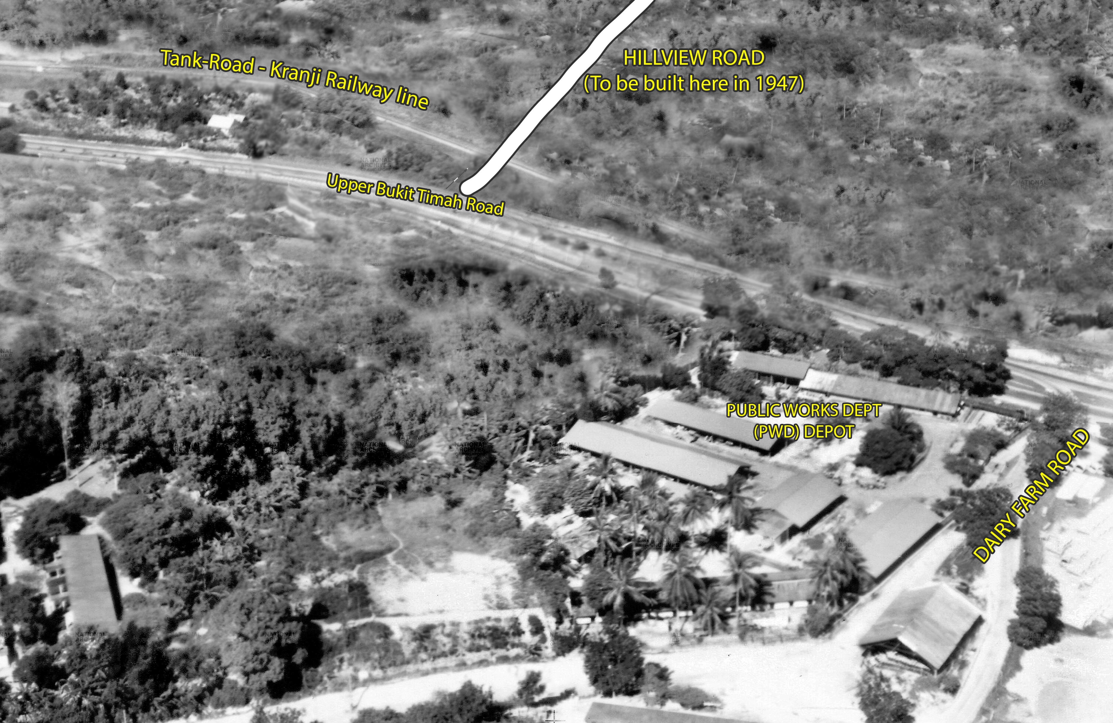
The Tank Rd-Kranji railway running down from the terrace.
The future Hillview Road would be built here in 1947.
The buildings at the bottom were the PWD Depot at Dairy Farm Road.


This is a map from 1898 of Singapore (from the YaleNUS/NLB collaboration online library)
that depicts the original Kranji to Woodlands railway line drawn through the 'Hillview' region.
The coloured overlay on the map was probably not on the original 1898 map
but was likely drawn in at a later date but before the completion of the railway line.


Thursday, August 18, 2022

World War Two battles around Hillview.

When World War Two descended onto Singapore in early 1942, the area that was to become Hillview in the future was still 'undeveloped' in the sense that we understand development today.

Located in the valley between the ridges of Bukit Gombak and Bukit Batok, the hill slopes were then covered mainly by rubber plantations on the Gombak slopes, while on the Bukit Batok ridge were remnants of old pineapple farms and some older gambier farms that had existed since the 1840s. This 'Hillview' valley stretch all the way from Bukit Batok hill north to the plains in front of what is the Ministry of Defence installation today. 

The only 'development' then in 1942 were the new factories of Ford Motors and the Hume Pipes Co., the more established Cold Storage Dairy Farm and the Nanyang Shoe factory at edge of Bukit Panjang Village. All these developments were along Upper Bukit Timah Road between the 8th & 10th milestones. Apart from these, it was mostly rubber plantations along the road.

It was an area that was still very ulu or rural, and at the periphery of the even more rural regions of Chua Chu Kang, Lim Chu Kang and Woodlands!

The invasion by the Japanese army towards Bukit Timah Village. 8-11 Feb 1942.
(click on the map for a detailed view)

The Japanese Invasion

On 8th February 1942, the Imperial Japanese Army invaded Singapore by crossing the Straits of Johore at the Sarimbun and Lim Chu Kang coast. 
Within the next 24 hours, the invading army had already conquered the entire Lim Chu Kang countryside and by afternoon the next day, 9th Feb, the British RAF Tengah airfield fell into their hands.

General Yamashita, the Japanese Army commander, who was nicknamed the Tiger of Malaya, had initially planned that the total conquest of Singapore would be completed by the 11th of Feb 1942.
However, his supply line was stretched too thin in Malaya and his army was running low on supplies, including food, fuel and ammunition by the time they had arrived at the Straits of Johore bordering Singapore.

Thus, he changed his immediate objective to the capture of Bukit Timah by the 11th of Feb instead.
Bukit Timah was where the British had their supplies, food stores and fuel depots and he coveted these supplies for his own men and army. 
Bukit Timah was also the highest point in Singapore which would afford the invaders a good view of the entire battlefield.
More importantly Bukit Timah was the major intersection where the main roads spread north, south and west of the island. Whoever controls the junction, controlled all movement to these areas.

With his objective set, his plan was to use two of his best army divisions, the 5th Division and and the 18th Division to capture Bukit Timah in a pincer movement. 
5th Division would moved along Choa Chu Kang and turn south at Bukit Panjang and head towards Bukit Timah with the support of Japanese tanks.
The 18th Division would move south-east through Bulim and along Jurong Road towards Bukit Timah Village, where they would converge with the 5th Division.
Both Divisions were given only 48 hours to accomplish this task of capturing Bukit Timah Village.

(There was a third Japanese Army Division called the Konoye Imperial Guards, but this unit was given a secondary task of moving across the Mandai and Thomson areas and played a more diversionary role to the main attack.)

Bukit Panjang
By the evening of the 10th Feb, the 5th Division had arrived at Bukit Panjang and was slowly maneuvering down towards Bukit Timah Village. They had fought and won fierce battles against the British at both Bulim Village and Keat Hong Village. By the time they arrived at Bukit Panjang, they also had the support of tanks which had been quickly pressed into service upon crossing the Straits of Johore.

At Bukit Panjang, the 5th Division was split into the three fighting regiments, the 11th, the 42nd and the 21st Infantry Regiments.
The 11th Regiment mauraded through Bukit Panjang Village and followed the water pipeline towards Bukit Timah via Dairy Farm, while the 42nd Regiment accompanied and provided infantry support for the tanks going down Upper Bukit Timah Road.
The 21st Regiment took the path along the Malayan Railway line and moved into the Hillview valley. This last group was given the task of capturing both the Ford and Hume factories.

Jurong
Over at the Jurong area, the 18th Division moved through the Bulim rubber plantations relatively easily till they came to Bukit Batok where they were met by the British Indian Army's 15th Infantry Brigade.
With their superior numbers and battle-hardened tactics, the Japanese forces routed the British army brigade at Bukit Batok.

Capture of Bukit Timah
By the late morning of the 11th Feb, both Japanese 5th and 18th Division had overwhelmed the British defenders at Bukit Timah Village and secure the high point of Bukit Timah hill.

Surrender
Following this victory, General Yamashita gave an ultimatum to the British to surrender.  However, the war in Singapore continued until for a few more days until the British finally surrendered on the 15th Feb, the first day of the Chinese New Year in 1942.
Three and half years of brutish Japanese Occupation was to follow for the citizens of Singapore.

For those who find this article TL;DR, I have actually done two videos on the same subject.
You can watch the video on Youtube at these links:-


Part 1. The Battle of Choa Chu Kang


Part 2. The Battle of Bukit Panjang

Further related links:-
Post-war history of Hillview