
Showing posts with label gambier. Show all posts
Showing posts with label gambier. Show all posts
Thursday, October 17, 2019
The arduous life of a gambier coolie in early Singapore
If you had been following my blog, you may come to realise that gambier is often mentioned in many articles. Why this fixation with gambier?
Was it because my forebears were gambier farmers? Was it because the Hillview region and Princess Elizabeth area, on which my blog is based, were all gambier farms in the past? Was it because most people today don't know about it? In a way, perhaps it's all these reasons. |
| A gambier processing facility, called a Bangsal, in early Singapore. Note the coolies bringing in their harvest of leaves. (Photo source: National Archives Singapore) |
My great-great grandfather, Mr Chua Chin Huat, a Teochew Catholic, started his gambier farm in the Chua Chu Kang area beside the Peng Siang River in the 1830s. He was the Kangchu and the farmland was called Chua Chu Kang, named after him. By 1855, it was recorded that he had 650,000 gambier plants and 105,000 vines of pepper on his farm.
Records also showed that he had to pay quit rent to the municipal government for 30 plots on his farm. This would imply that he might have up to 30 tenanted farmers, or coolies, working for him on his land. The coolies and tenant farmers lived a hard and impoverished life, some of whom were indentured labourers.
Gambir and pepper agriculture died out in Singapore by the end of the 19th century. Surprisingly, gambier farming still exist in neighbouring Indonesia but little in the way of life has changed for the gambier farmers today.
 |
| The flower of the Gambier plant, Uncaria Gambir. |
 |
| The leaves are where the gambier extract are derived. |
What is gambier?
Gambier is an extract from the leaves of a plant, Uncaria Gambir, which is only found in the Malay Archipelago. The processed extract was long used by the Chinese for medicines and for chewing the betel nut quid. Later, it was discovered that the tannic acid from the gambier plant was an excellent agent for use in tanning leather, and was very much cheaper than using European oak tannins. This discovery caused a boom in the the gambier trade with an insatiable demand from Europe. Today, gambier extract is used mainly for cosmetics and dyeing.
 |
| Raw gambier extract. Gambier plants can been in the background. |
Gambier was traditionally carried out on a shift agriculture basis. When the soil had been exhausted of its nutrients, the farmers will move to a new plot to grow new gambier plants. The old plots would be used for growing pepper, with the old processed gambier leaves used as fertiliser.
Gambier is an astringent plant, which means that its potency will diminish quickly and has to be processed immediately on harvesting.
The following photos show how gambier is extracted and processed. It is still done by small farm holders through a long laborious method that has hardly changed since the 19th century.
 |
| The gambier leaves are harvested when is it between 4-6 months old. |
 |
| This is a typical Bangsal, a Malay word for Shed. It's where the gambier is processed. It will contain a huge kuali, or cooking pot, where the leaves are cooked. Usually located near a stream where copious water is available. There may be many bangsals located within the same farm. |
 |
| The gambier leaves are harvested and brought directly to the bangsal for processing. Note the similarity to the 19th century picture, at top, and the bamboo basket which has not changed in design. |
 |
| The gambier leaves are stuffed tightly into a wicker basket. |
 |
 |
| The entire basket of gambir leaves is boiled until the leaves turns brown. |
 |
| The cooked leaves are removed from the boil and tied into a bundle for the next stage. |
 |
| The hot bundle is placed into a press to extract the juice from the leaves. Once the juice is extracted, the leaves are re-boil for a second pressing. |
 |
| Today, a hydraulic press is used. The only advance since the early days. Previously, heavy rocks were placed on top and pressure was applied manually with a long pole. |
 |
| The gambir extract is collected and poured out into trays and left to dry. |
 |
| When the extract becomes a semi-solid compound, it is formed into bricks. |
 |
| The bricks are left to dry in the sun. This is the end of the raw process. From these dried bricks, it is sold to be further processed into other products. |
Following are some vintage photographs of actual gambier farms taken in the 1890s.
 |
| Coolies gathering the gambier leaves into baskets. |
 |
| Gambier processing 'Bangsal' or processing shed. |
 |
| Inside the processing bangsal where the gambier leaves are cooked and pressed. |

Wednesday, September 18, 2019
An anecdotal history of Hillview Part 1. 1840-1945.

Prologue
When I first sat down to write this blog article, I thought of doing a history of Hillview from the present to as far back as records can tell. But I found it really hard going given the lack of resources and data available.So instead, I'll pen a brief anecdotal history, in the grand tradition of Mr Charles Burton Buckley, from past to present, highlighting some important events with regard to the Hillview region and Princess Elizabeth Estate. Some of the details have already been published in various articles within this blog. I welcome any reader to add to this chronology. You can comment in the section below (though I would appreciate that you leave a name and not as 'anonymous' please).
An anecdotal history of old times in Hillview Part 1.
1844 - John Thomson creates Upper Bukit Timah Road.
The earliest reference to the Hillview* area comes from John Turnbull Thomson, who was the Surveyor-General for the Straits Settlement in 1841, as well as being the Superintendent of Roads.
His major contributions to early Singapore were the drafting of the town map, the marine surveys of the harbour and the Straits of Singapore, and the construction of Horsburgh Lighthouse at Pedra Blanca. (Yes, Thomson Road is named for him)
* I use the term 'Hillview' here generically for convenience and ease of reference, even though it was not called as such till much later. This would be the region approximately from Bukit Batok hill to the base of Bukit Gombak, opposite St Joseph Church.
In 1844, John Thomson proceeded to survey and to establish a road beyond Bukit Timah Village, which was then the northern-most known and accessible village in the interior of Singapore.
Going through the jungle on horseback, and taking four days to survey and map a route that had been used by the pepper and gambier farmers, he marked out what would become the basis for the future Upper Bukit Timah Road and Woodlands Road.
 |
| Picture of a pepper farm, late 19th century Singapore. Pepper was planted on the same plot after the Gambier plants matured and could no longer be grown on the same ground. |
He recalls in his 1864 book, 'Glimpses into Life in the Far East', that despite the jungle, many areas were already studded with gambier farms. His survey indicated that the farms stretched for 3 to 4 miles from Bukit Timah Village. (Note: Gambier can also be spelt Gambir)
His initial destination was the Teochew village of Bokokang at Kranji, which was already a known kangkar along the Kranji River, but which was then only accessible by boat, via the Johore Straits.
You can read my account of this village at this link.
 |
| An extract from the 1846 map by John Thomson showing his route to the north from Bukit Timah Village in 1844. |
From Bokokang, he continued his overland survey till he reached the Straits of Johore, and thereby claimed the title of being the first person to make an overland crossing of Singapore Island.
1861 Crown Colony Survey.
The next time we hear of the Hillview region was in 1861 when a land survey of the gambier and pepper farms was done for tax assessment. This survey showed that the region below Bukit Gombak was divided into twelve large farms (or plantations).
 |
| Extract of the revised colonial survey 1872. (Source: NAS) |
Interesting to note was that a large portion was owned by Pedro Tan No Kiah, who was a very prominent Chinese merchant and Kangchu in the early days of Singapore. He was also known for being the first local Chinese convert to Roman Catholicism, having been baptised at the Good Shepherd Church in 1839.
A surprise was in store for me when I tried to superimpose the 1861 survey over a modern Google map of the area. This was how it looked when I first tried it.

After some fine tuning and adjustments, I realised that the farm boundaries matched the major roads that are still found there today. These included Hillview Avenue and its branches, Hillview Road, Lorong Taluki, Jalan Remaja. The condominium plots also coincided and were bound within the farm boundaries.
I have coloured the farms in a 3D version (photo at top of page) and you can clearly see the divisions and gambier plots against the residential housing today.
Decline of gambier and the rise of rubber
Very little record exist after the 1861 survey but we know from local history that from the 1870s onwards, gambier farming was in decline in Singapore due to soil exhaustion and were slowly being replaced firstly by pineapple, and later, rubber trees.
Gambier was an ecologically destructive plant. Not only did it completely leached the soil of nutrients but processing the gambier itself required huge and constant amount of firewood. This led to massive deforestation of Singapore's primary forests.
It was estimated that gambier agriculture caused the loss of 75% of Singapore's forest cover by 1900. Even back in 1856, the famous naturalist, Alfred Russel Wallace, had noted the incessant cutting of trees. Wallace was based at the St Joseph Church nearby and collected his nature specimens in the region surrounding the church. This would most likely have included the Hillview area.
In fact, colonial records remarked the existence of a sawmill in Hillview area, only that it was never mentioned exactly where it was, and no other corresponding record has ever been found yet to confirm its location.
It is very telling even from the 1861 (and a later 1872) survey that changes were already taking place in the gambier business. Farms were now in the name of non-resident owners like Tan Noh Kia and J. Jacobs, and that they were no longer referred to as "Chu Kangs". We know from local history that by the 1870s, most of the gambier farms were failing and many original farmer/owners were in debt to financiers from the city like Tan Noh Kiah, Seah Eu Chin, Tan Tock Seng and others.
Gambier farms all but died out by early 1900s and were frantically being replaced by the new wonder crop - rubber trees! All this as a result of the tenacious foresight of Henry Ridley, coupled with a boom in demand for rubber at the turn of the century when automobiles became the rage worldwide. Besides tyres, there was also a great demand for its use as insulation for electrical cables. However, rubber trees took about 10 years to mature enough to tap its latex. In the interim, plantation owners grew pineapples while waiting for the rubber trees to mature.
 |
| Hillview would be planted with pineapples while waiting for the rubber trees to mature. It took between 5 to 10 years before the rubber trees can be tapped for latex. |
The Singapore-Kranji Railway crosses Hillview.
In 1903, the Singapore-Kranji Railway, a.k.a. the Tank Road-Kranji Railway line was laid, running on the Bukit Timah side of Hillview.
The railway line from the city continued from Bukit Timah Station (BT Market today), ran across Bukit Timah Village towards the (Bukit Batok) hill where Ford and Hume factories would be built years later, and then ran alongside the main Upper Bukit Timah Road up to Bukit Panjang and beyond to Woodlands. At Hillview, the line was just above the road level, and not on the raised bank that would be used by its later replacement, the KTM railway.
 |
Look carefully and you can see traces on the ground left behind by the original Tank-Road-Kranji Railway Line.
It ran alongside and parallel to the main road. (RAF Photomap of 1950)
|
Pre-World War II period.
By the 1930s, one name became very prominent as a landowner in Hillview. This was Lee Kong Chian. By then, Lee had apparently obtained titles to the former gambier farms and began to convert these to planting of rubber trees.
It can be presumed, based on the agricultural business model of that time, that because Lee Rubber Co had bought up most of the gambier lands at Hillview, they would have planted rubber trees, and in the interim, fields of pineapples in between the rubber plots, until the rubber trees matured.
Examining the above 1950 photomap of Hillview, you can still see remnants of rubber trees on both sides of Upper Bukit Timah Road. The giveaway is the regular grid pattern that rubber trees were planted in. These are clearly seen beside Malayan Guttas, the bottom left at the Chinese kampong and the area above the Worker's Housing (Fuyong Estate) built by Lee Kong Chian.
A surviving remnant of Lee Rubber plantation can still be seen today on the southern ridge line of Bukit Gombak. These trees survived because they are located within the protected Mindef fence line.
 |
| A rubber plantation in Singapore in 1915. The workers are collecting latex for processing. |
 |
| The Lee Rubber Co processing factory at Sungei Kadut. |
In 1929, the Cold Storage Co Ltd bought 28 hectares of land that were formerly gambier farms across the road from Hillview. They converted these farms into pastures and created a dairy to supply milk to the local market. This was called Cold Storage Dairy Farm.
 |
| Dairy Farm pastures were created from former gambier farms. |
Hillview as part of the Bukit Timah Industrial area.
When Singapore was part of the British Crown Colony, industrialisation was furthest from the minds of the governors. Their interest laid first in using Singapore as a naval base, and equally important as an entrepot for shipping and trading in resources like tin, timber and rubber which came from the Malayan hinterland.
Given its laissez-faire environment, Bukit Timah Road slowly developed as the main industrial zone, ideally given that it was the only trunk route for resources from Malaya. Factories were set up all along the way and in 1938, Hillview saw its first major corporation.
In 1938, Australian subsidiary, Hume Pipes (Far East) Co Ltd secured a land grant of more than 20 hectares to set up a manufacturing plant at the 8th mile Upper Bukit Timah Road. It was to produce concrete-lined steel pipes for which it held a worldwide patent. Construction of the factory began in 1939 and was slated for completion by the end of 1941, when its manufacturing would shift from Dunman Estate to the Hillview plant.
 |
| Hume Pipes (Far East) Co Ltd |
 |
| Ford Company (Malaya) Ltd |
In 1939, Hume Pipes Co. leased 3-1/2 hectares of its land to a Canadian subsidiary of the American Ford Motors. This was to become Singapore's first motor car assembly plant, Ford Company of Malaya Ltd. Construction of the assembly plant began in 1940 and was completed in October, 1941.
 |
| An aerial view of Hume and Ford factories taken in the 1960s showing the extent of land occupied at Hillview. |
The Japanese Invasion, the battle at Bukit Batok and the Syonan-to years.
On 8 December 1941, the Imperial Japanese Army made a stunning bombing raid on Singapore as part of its invasion of South East Asia. War had arrived in Singapore and the Malay Peninsula. It was not until 8 February 1942 that the Imperial Japanese Army crossed into Singapore Island at the poorly defended Sarimbun beach.
The British defenders rushed to set up a blockade not far west from Bukit Gombak. This was the Kranji-Jurong Line, running from Bulim to Hong Kah, where today Tengah New Town is being built.
Strategically, this might have actually stopped the invasion in its tracks, except that the Line didn't hold. Due to massive mis-communication and poor command decisions, the units holding the Line started falling back, resulting in a domino effect and the complete breakdown of the blockade.
 |
| Sketch of the retreat of British forces from the 'Kranji-Jurong Line' 10th Feb 1942. |
On the morning of 10th Feb 1942, knowing that they were almost surrounded, the 15th Indians and the Special Reserves, tried to retreat to Ulu Pandan through Sleepy Valley. They walked right into an ambush, and tragically, of the 1400 men from both units, only 400 British troops survived and made it to Ulu Pandan. It was the biggest single day loss for the British Army fighting in Singapore.
You can read more details of this Battle of Sleepy Valley in this link.
By the morning of 11th Feb 1942, Bukit Timah Village was captured in a pincer movement by the Japanese Army coming down from both Jurong Road and Upper Bukit Timah Road.
With Bukit Timah Village secured, the Japanese commander, Lt-Gen Yamashita, moved his field headquarters to the newly-built Ford Motor Co factory at Hillview. From this location, Yamashita planned his final thrust. The British surrendered Singapore to the Imperial Japanese Army on 15th February 1942. The official surrender took place at the Ford Motors factory at Hillview.
With that, Singapore was re-named Syonan-to, The Light of the South.
At Hillview, the new factory of Ford Motors was seized and put into production by the Nissan Company to produce trucks for the army, while Hume Pipes was made to produce pipes and construction material for their war efforts.
 |
| The British Surrender Party marching up the road to the Ford Motors factory on Bukit Timah Road. 15 February 1942. |
 |
| General Arthur Percival, GOC Malaya, signing the surrender document at the Ford Motors Factory board room. Sitting opposite him is Lt-Gen Tomoyuki Yamashita, Commander of Japanese Forces. |
After Singapore surrendered in 1942, the Japanese military decided to build a War Memorial dedicated to their fallen comrades-in-arms. The memorial was to be built on Hill 345 at Hillview where many of their comrades had fallen during the Battle for Singapore. (It was not called Bukit Batok hill at that time.)
In contravention of the Geneva Convention, Prisoners Of War were used to built the Memorial. British and Australian POWs were marched daily from Adam Road Camp, Sime Road Camp and Reformatory Road Camp to built both the road and the hilltop shrine. The shrine was called the Chureito Syonan. It was completed and dedicated on 7th December 1942.
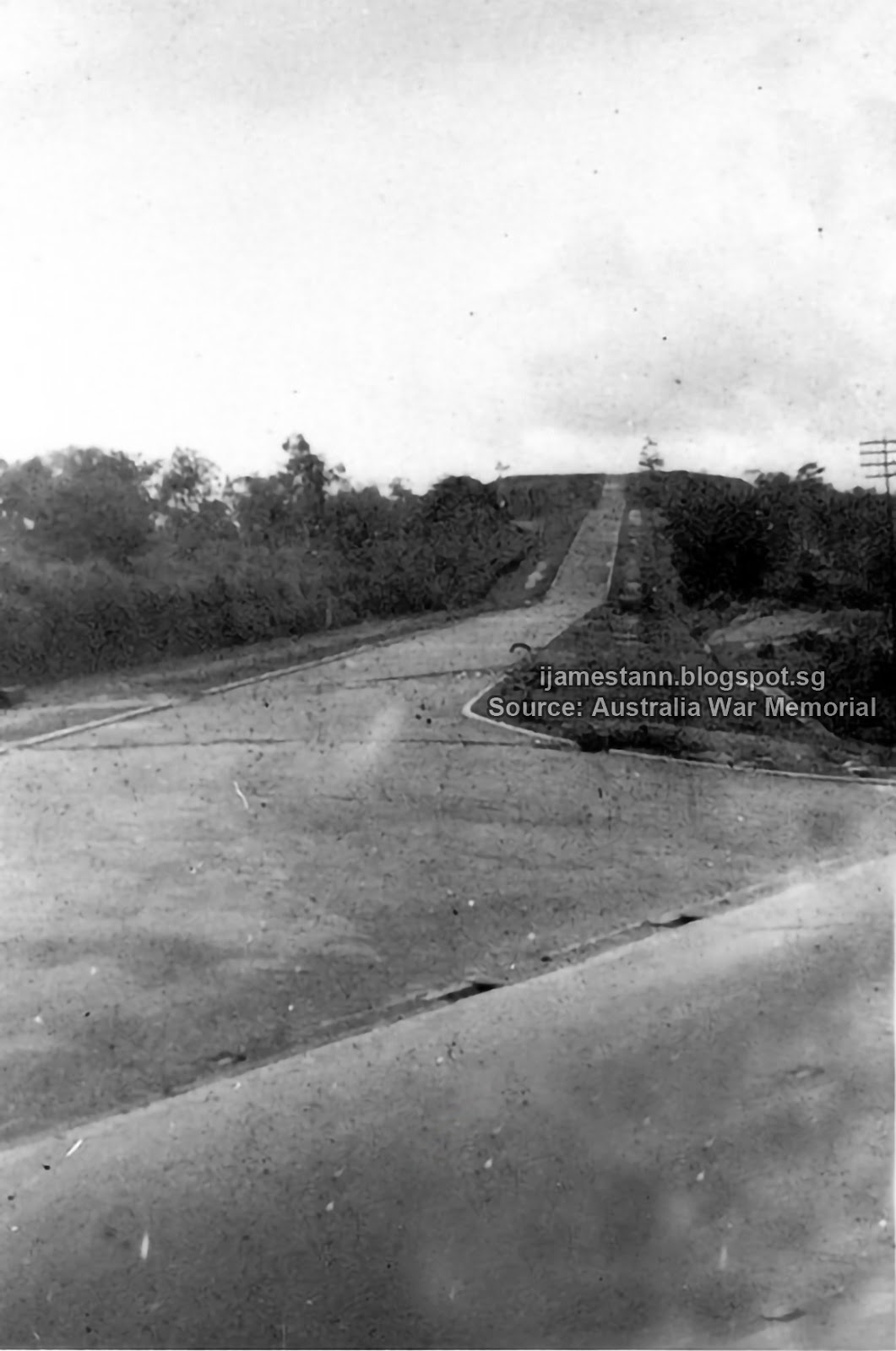 |
| The road from Upper Bukit Timah to the top of the Memorial Today, it's called Lorong Sesuai but has been truncated due to road expansion. |
 |
| The Japanese war memorial Chureito Syonan. Picture taken during the dedication ceremony held on 7th December 1942. |
 |
| The British troop were allowed to build a smaller memorial behind the shrine, a 15 foot Cross. This was also dedicated on the same day as the Chureito Syonan. |
 |
| 7th December 1942, Dedication of the War Memorials at Bukit Batok. |
Part 3: The industrialisation and gentrification of Hillview.

Monday, September 29, 2014
Bokokang - a village from our past.
Bokokang is a place you probably would not have
heard of; much less know that it was in Singapore!
Its heydays were between the
1840s, a couple of decades after Raffles founded Singapore, to the 1870s. Sadly by the early 20th
century, it fell into obscurity and was hardly heard of anymore.
 |
| 1852 map of gambier farms in Northern Singapore. |
Bokokang, (or variously spelt Bookoh Kang,
Buko Kanka, Bookoh Khan) was a Teochew village located on the Pang Sua River, a tributary of the Kranji River. It was one of the ‘Chu Kangs’ of the day much
like Lim Chu Kang and
Chua Chu Kang.
The Bukoh clan founded it before 1840 but the exact date is unknown.
Bukoh Ah Kee was the founder and he died on 27 June 1864. The leadership then passed to his son Bukoh Boh In, who was later succeeded by Bukoh Chew Kang.
The village was originally known as Bukoh Chu Kang but shortened to Bokokang as time passed, and the name became anglicised in the official records. The earliest record of this name was by government surveyor, John Turnbull Thomson, in 1844.
Chua Chu Kang.
The Bukoh clan founded it before 1840 but the exact date is unknown.
Bukoh Ah Kee was the founder and he died on 27 June 1864. The leadership then passed to his son Bukoh Boh In, who was later succeeded by Bukoh Chew Kang.
The village was originally known as Bukoh Chu Kang but shortened to Bokokang as time passed, and the name became anglicised in the official records. The earliest record of this name was by government surveyor, John Turnbull Thomson, in 1844.
 |
| A Chinese village around 1900s. Bokokang would typically look similar. (Photo source: National Archives of Singapore) |
Why was Bokokang so significant?
Despite being unknown to most people today, even
to those studying local history, Bokokang featured prominently in the early
days of Singapore. There were several reasons for its pre-eminent status.
Bokokang had a kangkar, or village centre, in that gambier and pepper-growing region of northern Singapore that became the most important trading port for that region. Its location was always marked on early maps of Singapore.
Bokokang had a kangkar, or village centre, in that gambier and pepper-growing region of northern Singapore that became the most important trading port for that region. Its location was always marked on early maps of Singapore.
 |
| Photo source: National Archives of Singapore |
I first heard of
Bokokang about 30 years ago when I was doing a study of the early catholic
church missionary activities and the early gambier farmers in Singapore.
Gambier was already being farmed here by the Chinese even before Raffles established a trading post in Singapore. Then they were mainly used for medicinal or personal consumption. However, when it was discovered that gambier could be used for tanning and dyeing, the demand from Europe was so overwhelming and the profits from it so lucrative that every farmer wanted to plant gambier. Gambier became the cash crop that fuelled the early economy of Singapore.
Gambier was already being farmed here by the Chinese even before Raffles established a trading post in Singapore. Then they were mainly used for medicinal or personal consumption. However, when it was discovered that gambier could be used for tanning and dyeing, the demand from Europe was so overwhelming and the profits from it so lucrative that every farmer wanted to plant gambier. Gambier became the cash crop that fuelled the early economy of Singapore.

 |
| Photo source: National Archives of Singapore |
It was to the industrious Teochew farmers who sought and opened up the lands in
the ‘unwanted’ jungle areas to capitalise on this demand. Concessions known as
chu kangs were setup in the North, West and North-Eastern areas of Singapore.
These chu kang lands came to be known by the name of the headman (the kangchu)
who held the concession. Thus, major farm areas came to be known as Choa Chu
Kang, Lim Chu Kang, Yeo Chu Kang, Tan Chu Kang, et cetra.
By the 1850s, there
were more than 26 major chu kangs known to the colonial administration. All these
chu kangs grew gambier and pepper with many of these farms being sub-divided
and tenanted to smallhold farmers.
In 1855, a survey done for the purpose of adminstering taxes, showed that the biggest chu kang in Singapore then was Bokokang, which had 426 coolies working on its lands.
In 1855, a survey done for the purpose of adminstering taxes, showed that the biggest chu kang in Singapore then was Bokokang, which had 426 coolies working on its lands.
 |
| A government survey map (1900) of the Bokokang area showing farm boundaries. Source: National Archives of Singapore |
Bokokang by then was an
established trading kangkar and commerce was all by river boats that had to
travel around the coast to the city merchants to trade. Travel across the island was not practical
due to the dense jungle as well as the threat of man-eating tigers.
The first cross-island overland passage
In 1845,
government surveyor John Turnbull Thomson, who was also at that time the
appointed Superintendent of Roads, conducted a mapping survey from Bukit Timah Village heading towards the village of Bokokang. Together with his companion, Dr Robert
Little, they marked out a route that was previously known to the local
villagers towards the north coast of Singapore Island. It was said that they took 4 days to map and mark the 7
mile route to Bokokang. This route would eventually became the road known as Upper
Bukit Timah and Woodlands Road.
From Bokokang, JT Thomson proceeded to survey the route towards the coast at Kranji, thus
claiming the title of being the 1st to make a cross-island passage from the
city to the northern coast. In its earliest form, this entire road was known as "Kranji Road".
 |
| From John Thomson's map of Singapore published in 1846. The map marks Bokokang as "Chinese Village" (This map was added to the blog on 27 April 2015) |
The first outstation church in Singapore
In 1846, the
Catholic Church established a small church at Bokokang called St Joseph Chapel.
A French missionary, Fr Mauduit, was sent to minister to the immigrant Chinese
Catholics who farmed around Kranji. This was the first Christian church to be
set up outside of Singapore City and Fr Mauduit was so successful in his
mission that by 1851, there were more than 300 Catholic converts at Kranji.
The
anti-Catholic Riot of 1851
As the British colonials had a laissez-faire attitude towards activities outside the city, the rural farmlands were mainly controlled by the Chinese triads, especially by the notorious Ghee Hin Huay secret society.
As the British colonials had a laissez-faire attitude towards activities outside the city, the rural farmlands were mainly controlled by the Chinese triads, especially by the notorious Ghee Hin Huay secret society.
One way for the
local farmers to avoid the threats and intimidations of the triads was to
convert to Catholicism. By doing this, they could look to the ‘foreign’
church for protection and they no longer were required to pay tithes
or protection money to the triads.
The increasing defection to the Catholic Church angered the triads so much that on 15 Feb 1851 the secret society declared war on the Catholic farmers. For a whole week, catholic-owned farms were pillaged, burnt and destroyed and the fighting was finally put down through the intervention of the military forces sent by the colonial government to quell the riot. The riot began at Bokokang and spread to other predominantly Catholic areas like Serangoon. This incident was known as the Anti-Catholic Riot of 1851.
The increasing defection to the Catholic Church angered the triads so much that on 15 Feb 1851 the secret society declared war on the Catholic farmers. For a whole week, catholic-owned farms were pillaged, burnt and destroyed and the fighting was finally put down through the intervention of the military forces sent by the colonial government to quell the riot. The riot began at Bokokang and spread to other predominantly Catholic areas like Serangoon. This incident was known as the Anti-Catholic Riot of 1851.
The decline of
Bokokang
Gambier was the
major cash crop grown in Singapore between the 1830s to its peak in the 1870s. However, gambier was a plant that was not
self sustaining nor was it environmentally-friendly. Gambier leached the soil
of all its nutrients so much so that within 15 years most of the soil became
infertile.
Further more, in order to process gambier, three times the amount of firewood in volume was required. The farmers had to constantly chop trees to fuel the cooking process. This resulted in devastating deforestation. In fact, by the turn of the century, it was reported that 75% of the tree cover in Singapore had been deforestation due to this agriculture. This alarmed the authorities so much that the central Bukit Timah region was declared ‘out-of-bounds’ to farming and made into a Nature Reserve to preserve what little was left of the primary forest.
Further more, in order to process gambier, three times the amount of firewood in volume was required. The farmers had to constantly chop trees to fuel the cooking process. This resulted in devastating deforestation. In fact, by the turn of the century, it was reported that 75% of the tree cover in Singapore had been deforestation due to this agriculture. This alarmed the authorities so much that the central Bukit Timah region was declared ‘out-of-bounds’ to farming and made into a Nature Reserve to preserve what little was left of the primary forest.
After the 1850s, the soil around Kranji was no longer fertile enough to sustain the gambier growth. Farmers began to look for land elsewhere. The Bukoh clan uprooted and sought new lands around Batu Pahat and Muar in Johore State.
In 1858, a priest from St Joseph Church led a group of 25 Catholic farmers from Bokokang to new lands in Johor. They set up a new settlement on a river that was given to them under a Surat Sungei concession from the Sultan of Johore.
The new settlement was called Pontian Kechil. The 25 farmers started the small town and the Catholic priest, Fr Augustin Perie, himself was instrumental in creating the road from Pontian Kechil to Ayer Hitam in Johore.
With the steady departure
of farmers for new farms in Johore, Bokokang went into decline. Additionally, with the opening of the trunk Bukit Timah Road, river transport became a slower and less viable option. The kangkar was no longer required for transporting the processed goods
to town.
Its demise was
sealed with the establishment of the Tank Road-Kranji Railway in 1903 that
totally bypassed the village. Through natural attrition, Bokokang was not heard of since.
 |
| Map of Kranji area showing the gambier and pepper farms |
Related links:
French Missionaries at Kranji
French Missionaries at Kranji
Subscribe to:
Posts (Atom)