Monday, August 16, 2021

The Singapore Quarry and the Chia Eng Say connection.

This article was written back in July 2011 and I transferred it here from my other travel blog as some readers have been enquiring about the Singapore Quarry and rather than re-directing them away. Edited Aug 2021.

Strangely, small coincidences seem to keep popping up in sequence for me.
It all started with the KTM railway closure. (click on link to go there)
Visiting the Rail Mall led me to Fuyong Estate and to Jalan Asas.
This then led me onwards to the old shortcut to the Singapore Quarry Park.
At the quarry park there is a plaque that reads "A Quarry story of....Chia Eng Say..."

The plaque at the Singapore Quarry Park.

Click to read the Ode mentioning Chia Eng Say.

Then just last night, I chanced upon a blog by a Kevin Lee mentioning a disused 'nameless' road running by Rail Mall train tracks. He wondered why it was there.
Wow, just what are all these coincidences ?
I realised the common link to them all is Chia Eng Say!


The original Chia Eng Say Road ran beside the railway truss bridge.
Now abandoned and covered with detritus.

A brief background to the man, the road and the quarry

Chia Eng Say Road was a private road built by the quarry company for access to their quarrying operations. It was the only access from Upper Bukit Timah Road to the quarries and ran parallel to the former KTM railway line. I can still recall trucks with their load of huge granite rocks rumbling along the road, off to some construction site somewhere in developing Singapore.

The road ran through a Chinese kampong known to us 'locals' as Kampung Chia Eng Say.
The kampong has been demolished and the homesteaders have been resettled in HDB housing, I presume. How sad.

Two of my old schoolmates used to live in that kampong, Quek Chee Ling and Wong Bee Leng. Alas, I've completely lost contact with them after our school days ended.
I can recall visiting them often at the kampong, especially during the times when the Chinese wayangs played during some religious celebrations.
I used to lived at Fuyong Estate that was just beside the old quarry worker's kampung.

A footbridge ran from Chia Eng Say Road over the KTM railway line.
This gave the kampong folks and quarry workers direct access to Upper Bukit Timah Road.

The cul de sac at Jalan Asas. The playground on the right was where the old kampong was located.

The secret shortcut to the quarry at the end of the cul de sac.

Who was Chia Eng Say?
Mr Chia Eng Say was what we would call an entrepreneur today. A multi-millionaire businessman from Fujian, China, who established businesses in Penang and Singapore in the early 1900s.
He apparently lived in Katong with his large progeny, believed to be 7 sons and 15 daughters in all!  Old newspaper announcements of the past had several reports of his sons and daughters being married off with grand dinners held at his mansion at Katong.

The Chia Eng Say Quarries
Chia Eng Say obtained the rights to mining the granite on the mid-western area of the Bukit Timah Ridge in the 1930s. There he started quarrying operations at two separate but adjacent sites facing the 8-1/2 milestone Upper Bukit Timah Road. The two adjacent quarries eventually merged into a single quarry. They were initially known as the Chia Eng Say Quarries. 

How it became known as the Singapore Quarry was simply a matter of convenience.
Chia had set up several subsidiary companies to run his quarrying business.
The major company was called the Singapore Quarry Co Pte Ltd, and this was the firm that undertook the actual mining.
After Chia Eng Say died in 1943, the business was usually referred to as Singapore Quarry.
The name became pegged to the actual quarry site itself. Thus, the Chia Eng Say Quarries became simply known as the Singapore Quarry.
The quarry was closed when the Singapore government ordered all mainland quarrying of granite to cease in 1970.

The private road, Chia Eng Say Road, located beside the railway truss bridge, became disused over time and was later expunged.  In the 1980s, NParks recovered the land as part of the Bukit Timah Nature Reserve. The quarry was to be converted into a nature park.
A new access path to the nature park quarry was formed from disused sections of the old Chia Eng Say Road.
The old name of Chia Eng Say Quarry was then replaced officially as the Singapore Quarry Nature Park.

Kampung Chia Eng Say
Chia Eng Say also built homes for his workers nearby, using the unallocated land that was beside the quarry adjacent Fuyong Estate. These were basically squatter land with temporary occupation licences given to Chia's company. Thus, colloquially, the kampung came to be known as kampung Chia Eng Say.

Chia Eng Say's legacy lives on
Besides being mentioned in the ode on the plaque, his name is now firmly entrenched nearby.
When the old shophouses at Fuyong Estate were re-developed into the Rail Mall, the little service access road in front of the shops was widened to a 2-lane road and the name Chia Eng Say Road was transferred to this upgraded stretch of road.

Trivia: In 1937, Chia Eng Say won the tender to supply all the granite to build the (old) Supreme Court building. The stones came from this quarry.


The service road in front of Rail Mall is now named after Chia Eng Say.


Below is an overhead aerial view of the Singapore Quarry
with the defunct Chia Eng Say Road leading up to it.


Friday, August 6, 2021

The reservoir dam at Bukit Gombak.

   On the evening of 15 July 2021, newsfeed and videos started trending on social media about a strange incident at Bukit Batok West Ave 5 beside the Gombak Stadium.
Muddy water was gushing out at a tremendous rate from a hillside near the Bukit Gombak MRT Station.


Videos above copyright and courtesy of Marcus Lim

One of these posts was from my friend, historian painter Mr Marcus Lim, who was an eyewitness to the event. In his post, he also pondered over what was happening. It was an incredible scene.

Oh Gosh! The Seng Chew Dam burst? I speculated.
Dam? Came the more incredulous response from Marcus.


In reality, what had happened was that a part of the Seng Chew lakeside wall had collapsed inwards after a few days of rain previously and slid into the lake. The landslide caused a mini-tsunami to overflow the top and gush down the hill towards the roadside at West Ave 5. The resulting deluge flooded the roadside, stopping traffic for several hours and bringing with it debris like tree branches, logs and lots of mud.


THE SENG CHEW QUARRY LAKE

Some of you may not be aware but there is a hidden lake high up on Bukit Gombak.

The Seng Chew Quarry Lake at Bukit Gombak


It was formed from the disused granite quarry that operated there from 1947 till 1970.
It was called the Seng Chew Granite Quarry.

This disused quarry was transformed and revitalised into a lake as part of the new Bukit Gombak Nature Park and Forest Trail. It was to be one of the several features of the new Bukit Batok Town Park that included the new sports stadium and the Little Guilin Park.
(Note: The Bukit Batok Nature Park is a different park about 2km away)

However, the Bukit Gombak Nature Park and the Seng Chew Quarry Lake were short-lived, and were soon closed to the public due to several recurring landslides that occured in that area. These occurred at several places like Chu Lin Park, the Forest Trail and at the lake side as well. The public thus were denied entry for safety reasons. Only the Little Guilin Park remained open to the public.

You can read some my earlier articles about the Bukit Batok Town Park and the Seng Chew Quarry at the links here, here, here or here et al.


This was a landslide into the lake back in 2014.


The lake boundary was fenced up for public safety.


Bukit Gombak Nature Park was closed due to recurring landslides.


This was the latest landslide of 15 July 2021 that caused the lake to overflow.


The debris and mudslide from the overflowing lake spilled onto the roadside below.


That may well have been the end of the story, but why did I exclaim that the Dam burst to Marcus' amusement?
Well, while some of you may know of the existence of this hidden lake, most of you will never ever know that there is a huge dam there at Bukit Gombak! Surprised?

It was so well engineered and built that you would never ever suspect that it is there.
Marcus would have been thinking I might be crazy when I said the dam burst, as would most of you. You have in your mind a dam such as the one like China's Three Gorges or Hoover Dam in USA.
A great hulking concrete structure holding back gadzillion tons of water and with a hydroelectric power station inside. Am I right? Touch your heart, ha ha.


THE SENG CHEW QUARRY DAM
The Seng Chew Quarry Dam is technically known as an earth-filled 'Embankment Dam'.

When the HDB was building Bukit Gombak New Town in the early 80s, they had a gigantic problem that they needed to settle. This was the scarred western hillside of Bukit Gombak where there were four huge former granite quarries. These were the Ideal Home Quarry, the Lian Hup Quarry, the Seng Chew Quarry and the Gammon Quarry. 
*(There was a fifth smaller quarry between Gammon and Seng Chew, but that will be fodder for a new article in future)

These quarries had gouged enormous holes into the landscape.  HDB architects decided to convert the quarries into nature parks as they were unsuitable for other major infrastructure then.  Both the Gammon and Seng Chew Quarries had to undergo major civil engineering works.

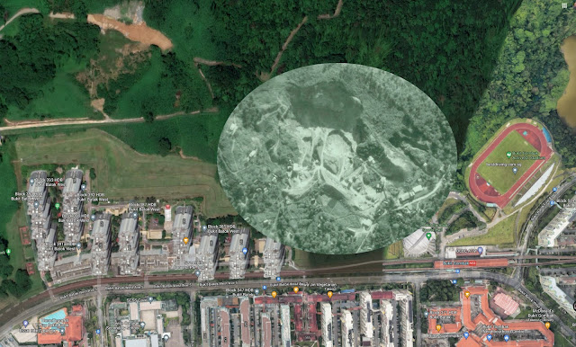
The aerial photo below shows the Seng Chew Quarry in 1956, in its ninth year of operations. There was another smaller adjoining quarry to its right by 1970 when it was closed but I cannot find a photo of that era. So you can imagine how much more wider the quarry face would have been after a further 14 years of quarrying.


This is the same 1956 quarry photo superimposed on a current Google map extract. The circle approximates the quarry-face size in 1970 according to topographic maps of the 70s. That was how much larger the quarry had grown before mining operations ceased. For reference, Bukit Gombak MRT Station is at bottom right.

Click on photo to see in full details.


The red circle represents the size of Seng Chew Quarry Lake today as it was planned by HDB to be part of the new Nature Park. 
In order to reduce it to that manageable size, they had to reinstate the entire hillside by building an earth dam over the entire area where the quarry once was. And so the 1st stage to constructing the lake was to build the new earth dam. Click on the photo above to see an enlarged view where you are able to judge the size of the 'hole' that they had to fill to build the earth dam.


The entire hillside between the Gombak Stadium and the Goodview Gardens HDB precinct
(left of pic) is in reality an earth dam that was built to enclose the Seng Chew Quarry Lake.


The hillslope behind the HDB's Goodview Gardens housing blocks are actually part of the earth dam.


This is the top of the earth dam that holds back the Seng Chew Quarry Lake reservoir. This was the zone where the landslide cause the lake waters to overflow and spill over the dam.
The drain on the right is known as a Spillway, it acts as a vent whenever the lake waters reaches a certain level and keeps the water level inside under control.
The sudden landslide on 15 July 2021 overwhelmed the capacity of the spillway and so the water simply overflowed this top but continued to follow the direction of the spillway.


The spillway drain after the deluge of 15 July.
Appears that some repairs will be needed soon.


So, in all essence, the spillway actually did its job well except that it wasn't designed for the kind of sudden volume that overwhelmed it that day.

My first instinct when I saw the video clips was that this area at the spillway top of the earth dam had collapsed and the earth dam had burst open. 

I reckoned that the earth dam is at least 300 metres wide and 30 metres high, holding back the reservoir that became the Seng Chew Lake. An amazing engineering feat. It had been so well incorporated into the landscape that almost everyone would never believe that it is a real dam.

So now you know that there is a huge earth dam at Bukit Batok.

Wednesday, August 4, 2021

The hidden waterfall at Bukit Batok


There is a beautiful cascading waterfall at Bukit Batok.
Most people would not even see it when it is in plain sight.
There is a magical secret to this!

Many of you may have noticed that even whilst we are in a pandemic situation, a lot of people have found new ways to relieve stress. One of the most visible that I have seen is that more people have been out to the parks, nature trails and forest reserves and in bigger numbers than the usual.

As a result of sharings on social media, more people are finding places that were once unknown to most.
Two of these lesser known places are the former Bukit Batok Hillside Park, as well as the Bukit Gombak Nature Park. They have been closed for more than twenty years now for various reasons, mainly for public safety.

In this article, I will tell you some secrets of the Bukit Batok Hillside Park located at Bukit Batok West Avenue 2, especially of its hidden waterfall.

Bukit Batok Hillside Park was created in the early 1990s. It was designed by the HDB based on a totally new concept then.
While most HDB neighbourhood parks were built within the housing precinct and thus would be basically 'flat' and built on cleared land making them easily accessible, the Hillside Park was designed to be a 'rugged' countryside park instead.

In early 1990, HDB's Principal Architect, Ms Evelyn Chua, on a trip to New Zealand was inspired by how the Kiwis preserved their natural terrain and natural vegetation in creating nature parks.

New Zealand Nature Park 

In trying to emulate this concept, HDB planners found that the hilly Bukit Batok region was ideal for this kind of natural rugged parkland.
It  had natural hills, was forested, had natural springs and had rocky outcrops to emulate mountain climbing features. Importantly, it was also isolated and away from the bustling new town, giving it a 'getting away from civilisation' feeling.

The intention was to keep it as pure and natural where possible. Making full use of the terrain, the rocky outcrops for hiking trails and using the forest flora supplementing it with local palms, ferns and rhododendrons for the more general public areas.

A lot of the secondary forest would be kept natural with only prepared trails in, to minimise damage to the natural vegetation. It would be a park not just for the general public but would also cater to those who prefer a hardier hike or climb or some jungle trekking.

For the general public, the Park was built with an 'enchanted forest' theme. There were cobblestone paths, a wishing well, floral pergolas and gazebos built all around the hillside where you could gaze on the developing Bukit Gombak New Town below. It would be like walking through a floral wonderland from one place to another through the pergolas to the gazebos.
But the best feature was a hidden waterfall that could be seen only when the conditions were right.

The Park was completed in early 1990 and was handed over to the Choa Chu Kang Town Council as part of their town facilities.  Choa Chu Kang Town Council was in charge of that area of Bukit Batok at the time as part of their constituency. The Town Council renamed the new park as Greenwood Park, however, the name did not last and was forgotten by most and was never included in further official listings when the park was closed for the reasons  I will explain below.


Photos by ©EngOng Bluefly


THE PUBLIC WAS NOT READY.

Alas, Hillside Park was not popular for the very same reasons that they expected that it would be.
It was too rugged, people found it too hard to climb about the rocky surface, the slopes were too steep for comfort, there were no handrails along the paths, and the park features felt a bit fake, a bit out of place.
Even simply to access the park, you had to climb a steep stairway of 10 metres just to reach the entrance. And it was too far away from most residents then, being isolated at the far end of Bukit Batok West at that time, while most of them were living in the eastern and central zones.

So the very reasons that they thought would make the park outstanding and unique became the very reasons for its downfall. 
The public, especially residents of Bukit Batok, were not used to this new concept and most gave the park a miss due to these difficulties. So visitor traffic to the Park dwindle to almost zero over the next few years. It was the wrong type of park at the wrong time.


The Wishing Well


For the Town Council, the park became a costly liability. It cost them more to maintain than there were visitors to justify its continued upkeep. However, they kept it going at that time as there were talks that a new statutory board was to be formed to take over the management of all parks in Singapore.

When NParks was formed to take over all Singapore parks, they decided not to upkeep the unpopular Hillside Park and so it was closed and left to fallow. It was eventually abandoned and the land was returned to the HDB.  Over the years since, it was literally forgotten except by the few hardy explorers and 'ghost hunters' and it became a hidden gem for birders.

You can watch the accompanying video clip below that will show you some of the remnants of the features that were in the park. The video was done more for the birding community but it will also show you a bit of the old park.
In this video, I also dispel the mistaken notion that the pergolas many hikers and explorers come across there were once Japanese "Torii Gates".

Definitely not Japanese Torii Gates!


SO WHERE WAS THIS WATERFALL?

One of the most unique features of Hillside Park, one that can still be seen even today after being abandoned more than 20 years, is the hidden waterfall.
On a fine day, you won't be able to find it but when it rains, it appears like magic in the enchanted forest.

The main access into the park was a man-made rock stairway leading to the Wishing Well and the Gazebos.


The unique feature of this stairway was that all the drains around the park were directed towards it.
Whenever it rains, all the runoff rainwater would be channeled into this stairway causing the rainwater to cascade down the steps.
The heavier the rainfall, the larger would be the cascading waterfall.
This effect can still be seen today whenever it rains.


When NParks closed Bukit Batok Hillside Park to let it revert into a secondary forest, they removed the bottom half of this stairway to prevent the public from getting inside. The stairway was also covered with new plants to hide the entrance. 


AN UNINTENDED DISASTER!

What NParks didn't realise then was that when the original hidden waterfall was put in, it was covered with a layer of Gunite (shotcrete). This layer of gunite, which is a type of concrete, was laid all over the stairway channel to prevent erosion of the soil when the waterfall effect happens during the rain.

HDB planners apparently knew that a gushing waterfall would soon erode the soil beneath but I guess NParks know more about flora and fauna than civil engineering. hee hee. just kidding.

NParks failed to recognise the ingenuity of the HDB architect's design.
Essentially, HDB had created a huge concrete 'longkang' (canal) to drain all the runoff rainwater away from the park. Creatively, they made that same longkang into a stairway as well. This canal/stairway would channel all the rainwater to the main drainage at the roadside. And in this process the magical waterfall would appear for those willing to wait in the rain.
Can you imagine what would happen if someone cut the longkang away?

As the erosion prevention layer was removed together with the lower half of the stairway, the bottom half of the waterfall channel has now eroded the hillside over the years and continues to pour rainwater and mud directly onto the roadside today.
The intact upper section of the stairway is still in excellent condition and hasn't eroded all these years.
The gunite layer also acted as a non-slip layer to allow people to walk through the cascade without falling.

LAST CHANCE TO SEE THE MAGICAL HIDDEN WATERFALL
Bukit Batok Hillside Park is slated to be re-developed for new flats over the coming years. A small replacement neighbourhood park would be built for the new residents on one side of the present hill by 2024. Today, Hillside Park has already been reduced to less than a quarter of what it originally was when it was built.
If you want to see this magical phenomena, go there soon before it is all gone.
But only when it rains!
If you intend to go further in, remember it is very, very slippery on the steep slopes during a rainfall.

Here is my accompanying video where you can see the fake cobblestone stairway that turns into a beautiful cascading waterfall during the rain.
If you prefer to watch in full screen or with subtitles, you can click on this link 


A word of thanks to my hiking friend Tan Kim Lai for the use of his photographs.