Muddy water was gushing out at a tremendous rate from a hillside near the Bukit Gombak MRT Station.
Videos above copyright and courtesy of Marcus Lim
One of these posts was from my friend, historian painter Mr Marcus Lim, who was an eyewitness to the event. In his post, he also pondered over what was happening. It was an incredible scene.
Oh Gosh! The Seng Chew Dam burst? I speculated.
Dam? Came the more incredulous response from Marcus.
In reality, what had happened was that a part of the Seng Chew lakeside wall had collapsed inwards after a few days of rain previously and slid into the lake. The landslide caused a mini-tsunami to overflow the top and gush down the hill towards the roadside at West Ave 5. The resulting deluge flooded the roadside, stopping traffic for several hours and bringing with it debris like tree branches, logs and lots of mud.
THE SENG CHEW QUARRY LAKE
Some of you may not be aware but there is a hidden lake high up on Bukit Gombak.
 |
| The Seng Chew Quarry Lake at Bukit Gombak |
It was called the Seng Chew Granite Quarry.
This disused quarry was transformed and revitalised into a lake as part of the new Bukit Gombak Nature Park and Forest Trail. It was to be one of the several features of the new Bukit Batok Town Park that included the new sports stadium and the Little Guilin Park.
(Note: The Bukit Batok Nature Park is a different park about 2km away)
However, the Bukit Gombak Nature Park and the Seng Chew Quarry Lake were short-lived, and were soon closed to the public due to several recurring landslides that occured in that area. These occurred at several places like Chu Lin Park, the Forest Trail and at the lake side as well. The public thus were denied entry for safety reasons. Only the Little Guilin Park remained open to the public.
You can read some my earlier articles about the Bukit Batok Town Park and the Seng Chew Quarry at the links here, here, here or here et al.
 |
| This was a landslide into the lake back in 2014. |
 |
| The lake boundary was fenced up for public safety. |
 |
| Bukit Gombak Nature Park was closed due to recurring landslides. |
 |
| This was the latest landslide of 15 July 2021 that caused the lake to overflow. |
 |
| The debris and mudslide from the overflowing lake spilled onto the roadside below. |
That may well have been the end of the story, but why did I exclaim that the Dam burst to Marcus' amusement?
Well, while some of you may know of the existence of this hidden lake, most of you will never ever know that there is a huge dam there at Bukit Gombak! Surprised?
It was so well engineered and built that you would never ever suspect that it is there.
Marcus would have been thinking I might be crazy when I said the dam burst, as would most of you. You have in your mind a dam such as the one like China's Three Gorges or Hoover Dam in USA.
A great hulking concrete structure holding back gadzillion tons of water and with a hydroelectric power station inside. Am I right? Touch your heart, ha ha.
THE SENG CHEW QUARRY DAM
The Seng Chew Quarry Dam is technically known as an earth-filled 'Embankment Dam'.
When the HDB was building Bukit Gombak New Town in the early 80s, they had a gigantic problem that they needed to settle. This was the scarred western hillside of Bukit Gombak where there were four huge former granite quarries. These were the Ideal Home Quarry, the Lian Hup Quarry, the Seng Chew Quarry and the Gammon Quarry.
*(There was a fifth smaller quarry between Gammon and Seng Chew, but that will be fodder for a new article in future)
*(There was a fifth smaller quarry between Gammon and Seng Chew, but that will be fodder for a new article in future)
These quarries had gouged enormous holes into the landscape. HDB architects decided to convert the quarries into nature parks as they were unsuitable for other major infrastructure then. Both the Gammon and Seng Chew Quarries had to undergo major civil engineering works.
The aerial photo below shows the Seng Chew Quarry in 1956, in its ninth year of operations. There was another smaller adjoining quarry to its right by 1970 when it was closed but I cannot find a photo of that era. So you can imagine how much more wider the quarry face would have been after a further 14 years of quarrying.
The aerial photo below shows the Seng Chew Quarry in 1956, in its ninth year of operations. There was another smaller adjoining quarry to its right by 1970 when it was closed but I cannot find a photo of that era. So you can imagine how much more wider the quarry face would have been after a further 14 years of quarrying.
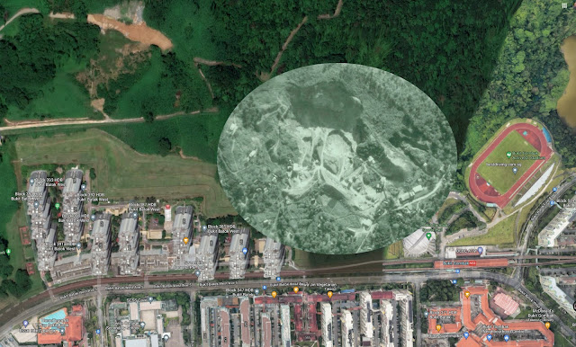
This is the same 1956 quarry photo superimposed on a current Google map extract. The circle approximates the quarry-face size in 1970 according to topographic maps of the 70s. That was how much larger the quarry had grown before mining operations ceased. For reference, Bukit Gombak MRT Station is at bottom right.
 |
| Click on photo to see in full details. |
The red circle represents the size of Seng Chew Quarry Lake today as it was planned by HDB to be part of the new Nature Park.
In order to reduce it to that manageable size, they had to reinstate the entire hillside by building an earth dam over the entire area where the quarry once was. And so the 1st stage to constructing the lake was to build the new earth dam. Click on the photo above to see an enlarged view where you are able to judge the size of the 'hole' that they had to fill to build the earth dam.
In order to reduce it to that manageable size, they had to reinstate the entire hillside by building an earth dam over the entire area where the quarry once was. And so the 1st stage to constructing the lake was to build the new earth dam. Click on the photo above to see an enlarged view where you are able to judge the size of the 'hole' that they had to fill to build the earth dam.
 |
The entire hillside between the Gombak Stadium and the Goodview Gardens HDB precinct
(left of pic) is in reality an earth dam that was built to enclose the Seng Chew Quarry Lake.
The hillslope behind the HDB's Goodview Gardens housing blocks are actually part of the earth dam.
This is the top of the earth dam that holds back the Seng Chew Quarry Lake reservoir. This was the zone where the landslide cause the lake waters to overflow and spill over the dam.
The drain on the right is known as a Spillway, it acts as a vent whenever the lake waters reaches a certain level and keeps the water level inside under control.
The sudden landslide on 15 July 2021 overwhelmed the capacity of the spillway and so the water simply overflowed this top but continued to follow the direction of the spillway.
 |
| The spillway drain after the deluge of 15 July. Appears that some repairs will be needed soon. |
My first instinct when I saw the video clips was that this area at the spillway top of the earth dam had collapsed and the earth dam had burst open.
I reckoned that the earth dam is at least 300 metres wide and 30 metres high, holding back the reservoir that became the Seng Chew Lake. An amazing engineering feat. It had been so well incorporated into the landscape that almost everyone would never believe that it is a real dam.
So now you know that there is a huge earth dam at Bukit Batok.


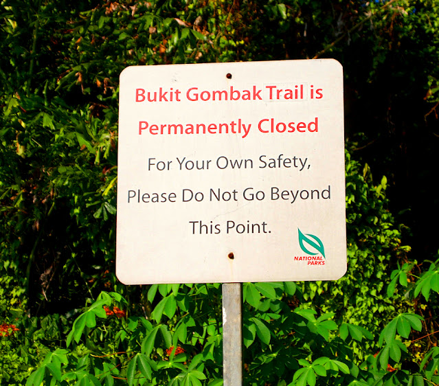
Seng Chew quarry is no longer accessible. A steel fence with a padlock gate stands over the spillway halfway to the quarry. Pity.
ReplyDeleteIt was always an 'out-of-bounds' area ever since they closed the authorities closed that section of Bukit Gombak Nature Park but it was never really enforced against the adventurous hikers or explorers and was simple bordered by a simple chain link fence. No major mishaps until the mini-tsunami. I guess it's all for safety sake.
DeleteInteresting story. I never knew there was a lake behind gombak stadium after staying in this area since 1988. I only know there is a lake at natural park and xiao guilin. But interesting part is back in the late 1980s and early 90s. My neighborhood friend's elder brother that drives their company vans always told us that they are going to wash their vans at the road side opposite blk 369. Back then cars were lesser and police were not so strict. They can pail at the road side and was saw them scooping buckets of clans water from the drains. That area seems to produce alot of free water. So these water actually came from the lake.
ReplyDeleteWhen I first moved to Bukit Batok in 1984, I was also one of those who used to drive to West Ave 5 to make use of the free spring water to wash my car. This was long before the MRT track and the flats by the hillside were built so that area was quiet and not a busy road.
Delete