Friday, August 30, 2013

The mysterious hidden lake of Bukit Gombak

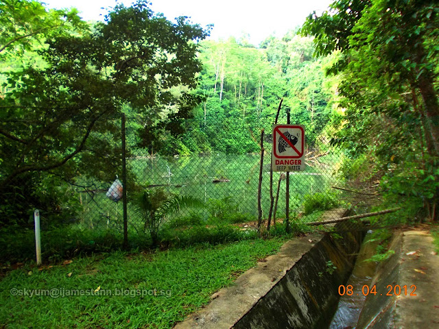
Following my earlier posting of a video clip of the stream flowing from Bukit Gombak, my friend SK Yum sent me some pictures he took while exploring Bukit Gombak with his children a year ago.

He was surprised to find a lake at the top of the hill. The lake is the source where the stream flows endlessly till this day.

Here are the pictures he took of the stream and lake.
Read on further to learn some surprising facts about this lake.


My sincere thanks to Yum Shoen Keng for providing the personal photos above.


Though the lake has been there for as long as most Bukit Gombak town residents have lived there, the lake was only formed in the late 1970s.
This was when the government closed all the granite quarries in Singapore, (except for Gali Batu) and restricted quarrying offshore to Pulau Ubin.

The lake was formed when water started to fill the pit that was the old SENG CHEW Granite Quarry at Jalan Perang. It continues to fill till this day.

The stream that flows out from this lake acts as an overflow vent to drain excess water should the lake fill to the brim, which happens during intense rainfall. Otherwise, the lake is constantly fed by the natural Gombak springs.

Though not officially restricted as an out-of-bounds area, the lake is cordoned off due to the danger of sudden drop offs. NParks does not encourage visitors there as it is undeveloped with hidden dangers.

The old Jalan Perang Taoist Temple.
In the olden days, there used to be several shrines and one major Taoist temple along Jalan Perang.
The Jalan Perang Taoist temple was noted by residents near and far for its effective talismans given out at this temple.  This Taoist temple also had waters springing from Bukit Gombak which were eagerly collected by worshippers for its 'magical' or spiritual qualities. This temple and all the minor shrines at Jalan Perang were demolished during the construction of Bukit Gombak New Town.


Sorry I am not able to elaborate more on the Taoist temple
(I am not taoist and depended on hearsay for info on it).


Related links:
The old Gombak Nature Trail photos
Streams at Bukit Gombak
Bukit Gombak Nature Trail article


Monday, August 19, 2013

A jungle dirt track saved 400 soldiers from certain death.

Unless you lived in the remote Choa Chu Kang area in the past, or unless you know your local geography or history really well, you probably would not have heard of Jalan Perang.

Before the 1970s, Jalan Perang was really a non-descript jungle track leading to places where people would not normally venture.
It ran along the western Bukit Gombak slope, running south from Choa Chu Kang Road all the way to Jurong Road.

Click on sketch to enlarge to full size.

This small dirt track was mainly used by kampong villagers to their smallholdings within the Choa Chu Kang/Jurong farmland as well as by trucks carrying granite from the 4 major quarries on Gombak Hill.  It looked exactly like the picture below, except I remembered it was much narrower.

One of the last few country dirt tracks left in Singapore now.
(Bahtera track at Sarimbun)
The track was called Jalan Perang in English, but rightly it should be in the Malay pronunciation of Pērang, meaning 'dirt track'. However over  the years, it became anglicised and pronounced as Perang (per-rung), which in Malay means war!
This brings me to the story which I will now tell you of how this dirt track became the salvation for 420 soldiers during the Japanese invasion of 1942.
On 8th Feb 1942, the Japanese Army crossed Johore Straits and invaded Singapore through Choa Chu Kang. The defending force there was the 22nd Australian Brigade led by Brigadier Taylor. 
However, the Australians were pushed back by the Japanese from Choa Chu Kang Sarimbun Beach all the way to the south of Tengah Airfield. There they set up a defensive blockade along Choa Chu Kang Road.  (See map below to have a clearer idea)
A reserve unit, called the Special Reserve Battalion comprising over 400 soldiers, was quickly despatched to Choa Chu Kang and given to Brigadier Taylor for assistance. They were ordered to defend the hills south of Choa Chu Kang Road near Bulim and were duly positioned there.
By the afternoon of 9th Feb, Brigadier Taylor withdrew his forces away from the battlefront to Ulu Pandan. In his haste to escape from the advancing Japanese, he forgot to inform the newly arrived Special Reserve Battalion about the withdrawal! 

Click on the map for a detailed view.

By the time the commander of the S.R. Battalion realised he had been abandoned by the 22nd Brigade, the Japanese forces had already bypassed his position in the north and south. Gallantly, the commander, Major Bert Saggers, led his men through the only way out, heading due East in growing darkness, all the time avoiding any contact with the enemy.
Fortuitously, he hit upon the dirt track and from then could make a speedy retreat towards friendly lines at Bukit Batok Hill. Thus, having saved his battalion of 420 soldiers from being annihilated by the surrounding Japanese forces. They then took up defensive position at a small hill at Bukit Batok facing the oncoming Japanese army along Jurong Road. Today, on the hill where they camped that night in 1942, stands the Church of St Mary of the Angels Bukit Batok.
Major Bert Saggers, was captured at the surrender of the British capitulation and was sent to the Thai-Burma Railway as a prisoner of war.  He survived and returned to Australia after the war.
Major Bert Saggers
Commanding Officer
Special Reserve Battalion, Feb 1942.


Today Bukit Batok West Ave 5 and Bukit Batok East Ave 5 follows the identical route that used to be Jalan Perang, all the way from Choa Chu Kang Road to Hillview Avenue.


Related links:
Tragedy at Sleepy Valley
Hillview Ave to Jurong Road

WW2 relic at Hillview Avenue

Sunday, August 18, 2013

The Holy Rock of Batu Lapan.

Exactly a year ago, I posted an article about the Keramat Habib Syed Ismail that was located opposite the Ford Motors factory at Upper Bukit Timah Road. (link here)

In it, I lamented the fact that I didn't have the foresight to take photos of that place then, even though I was an avid photographer at that time when the keramat existed. For a whole year since, I've searched and asked around to no avail.

Then a few days ago, on one of my facebook groups, a reader posted a 1906 photo and asked if anyone knew what it was?  I jumped out of my seat when I saw that photo.
Here was the picture that was posted in that facebook group.


This was 'The Holy Rock" that was located beside the waterfall at the old Singapore Quarry, a stone's throw away from the surau (prayer hall) at Kampong Merpati. This tiny kampong was located between the KTM railway track and the 8th milestone Upper Bukit Timah Road (known colloquially as Batu Lapan)
This was where the muslim mystic Habib Syed Ismail lived in the early 20th century and where he had a large following due to his religious 'enlightenment'.
When he died, he was entombed there and a keramat built to honour him. This was the Keramat Habib Syed Ismail.

As mentioned in my previous blog about the keramat, Habib Syed Ismail was venerated as a holy saint, even in his time.  It became legend that Habib Syed Ismail would go to his 'holy rock" to meditate and communicate with the spiritual world.  (Please note that there is absolutely no mention of who that person in the photo is)

The keramat became a place of pilgrimage for many, including many Chinese and Indians, seeking answers, supplications or favours. As a result of the posting on facebook, I was led to other details and managed to obtain old newspaper articles with regards to the keramat.

This is from the Straits Times of 25 Dec 1938 when an article regarding the old caretaker of the keramat Habib Syed Ismail was published. It had 2 pictures showing the keramat and are the only pictures of the place that I have seen till now.


The tomb of Habib Syed Ismail.

The Keramat Habib Syed Ismail at Batu Lapan.
The surau or prayer hall is beside the keramat.

I wonder if the small village was named Kampong Merpati (Dove Village)
due to the large flocks of pigeon as seen in the 1938 photo.
A part of the quarry can be seen in the background.
The KTM rail track would be between the kramat and the quarry.

The 1938 newspaper article was on the old caretaker of the keramat.
He claimed to be 142 years old and born in the year 1796 on April 4th. It was also mentioned that he saw Sir Stamford Raffles. The caretaker was named Mr S. Fareed. He had outlived all 11 of his wives.

Keramat caretaker, S Fareed.

* The keramat Habib Syed Ismail was demolished in the 1980s due to land acquisition and Habib Syed ismail was re-interred at the Choa Chu Kang Muslim cemetery.

Saturday, August 17, 2013

Streams of Bukit Gombak

If you have read some of my previous posts, you'll know that I have often mentioned about the streams that flowed copiously through our former estate. These streams originate from springs located within the hillside of Bukit Gombak.

So fresh and clear was the waters that the ecological life within it flourished, much to the delight of the residents and children, Fishes like guppies and barbs, crabs, eels, frogs and who knows what other creatures, thrived in the clean spring water.

This morning, I was walking pass the other side of Bukit Gombak, near the Gombak MRT station, when I noticed a drain was pouring water constantly downhill.
Immediately, I realised that this was one of the many streams that used to flow from the hill.

After posting my initial mobile phone video, I went back to do a proper shot later to show the spring flowing down the now concretised stream. The drain is actually an overflow spillway from the Seng Chew Quarry Lake.


The Seng Chew lake spillway.

I recalled that about 20 years ago, before they built the HDB flats and the MRT beside this stream, car owners, including myself, would drive to the roadside beside this stream to use the clean water to wash our cars.

You can see that Bukit Gombak still contains a lot of spring water that today continues to flow from the hill.