Saturday, June 30, 2012

Aerial View of Hillview 1950s


This is an aerial view of the Hillview Avenue area taken in the late 1950s.
Click on the photo to get a larger detailed view.
I have labelled a few prominent landmarks as follows:

A -   Princess Elizabeth Estate
B -   Hong Kong Rope Manufacturing Co
C -   National Carbon Co (renamed Union Carbide Co in 1957)
D -   Malayan Guttas Co
E -   Central Oil Refinery Co.
F -   Kiwi Polish Co Pty Ltd
G -  Malayan Spinning Mills
H-   Hume Industries
H1- Hume Industries Manager's Quarters (Hume Heights)
J -   Ford Motor Co.
K -  Gammon Malaya Ltd
L -  Dairy Farm
M - Dairy Farm Granite Quarry (PWD)
N - Salvation Army / Lee Kuo Chuan Home
O - The Chartered Bank
P - Fuyong Estate
Q - Singapore Granite Quarry
X - Bukit Batok Hill
Z - F. E. Zuellig (M) Ltd (see TG Chua's comments below)


Related link: Development of Hillview Avenue

Tuesday, June 26, 2012

Photos from ex-residents (4)

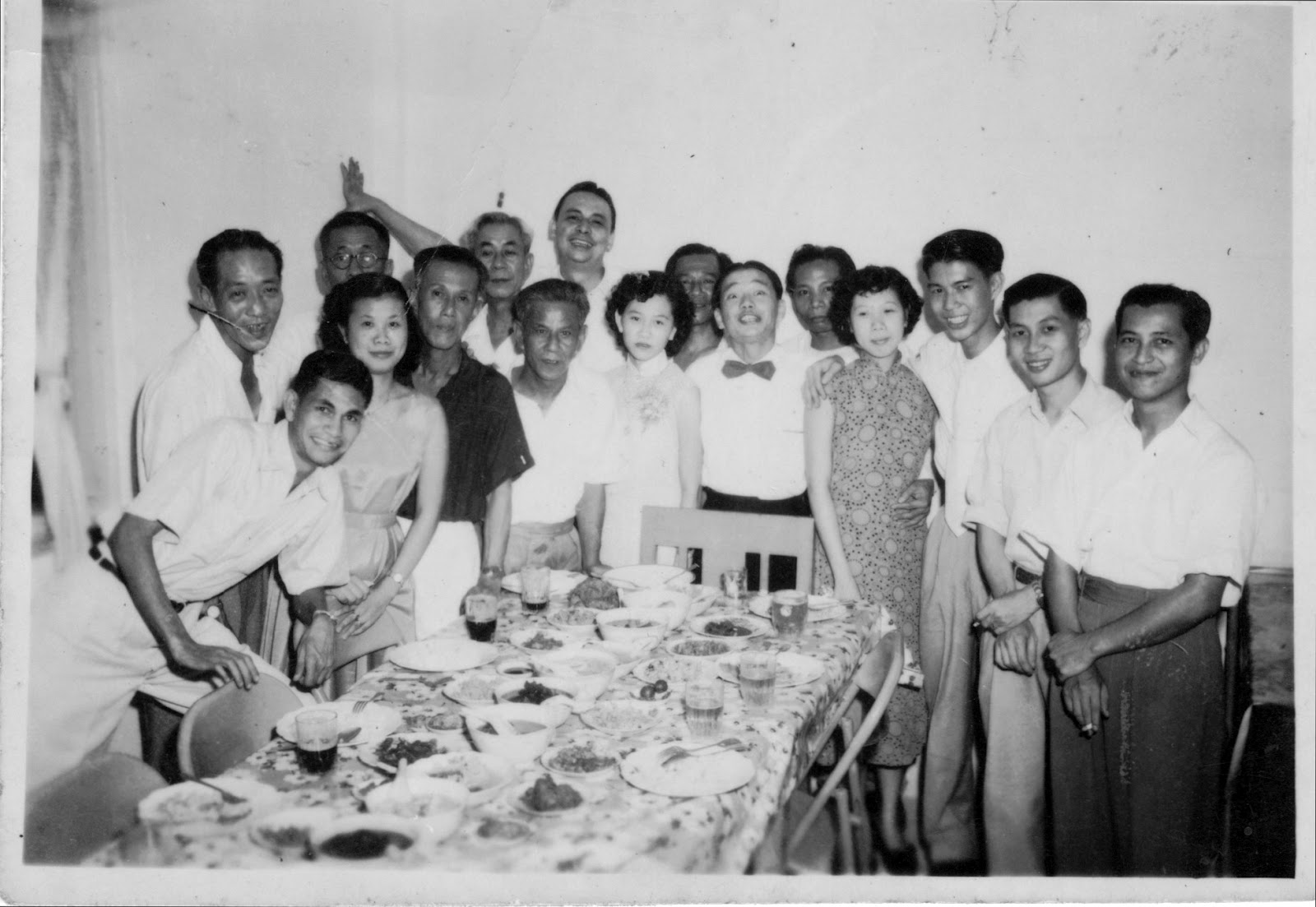
I received 2 photographs from an ex-resident who wishes to remain anonymous.
The photos were taken almost a generation apart. Some of the children in the 2nd photo have parents featured in the 1st photo!

If you can identify any of them, please send me a email.
(I hope my friend Lowy can be of assistance here as she seems very good at identifying the ex-residents.)


Photo of staff of National Carbon (Union Carbide) and friends having a celebration at a house at Princess Elizabeth Estate. Taken around 1953.
L-R: 1. Lee. 2 Maxie,  3. Bongsu (Mrs Joseph Lee),  4.unknown(back), 5 Yap ___?, 6 Goh Tong Liang, 7 Goh Tong Siew, 8. Hogan, 9 Agnes Goh, 10. unknown (behind), 11 Koh Keng Kwee, 12 unknown, 13 Mrs Leong Wah Tim, 14 Leong Wah Tim, 15 Peter Leong, 16 Joseph Lee.
(Click on photo for enlarged view)

Photo of a children's party taken around 1960.
L-R: Stephanie (looking right), Leong Chee Hong, Betty Lee, Anne Moss, June Moss.

Saturday, June 23, 2012

Bukit Batok Hill

As a child, I lived at Princess Elizabeth Estate built on the flanks of Bukit Gombak hill.
In my youth, I moved to Fuyong Estate on the slopes of Bukit Timah Hill  before returning to Princess Elizabeth. Now as an adult, I live at Bukit Batok.
This meant that all my life, I have been domicile within an area of less 3 km from each another.
So I am truly a 'swa teng' person and my 'kampong' can be considered as the Hillview/Gombak/Bt Batok & Bt Timah area.

Central to this area is Bukit Batok Hill at 120m high.
As I previously mentioned in other articles, Bukit Batok Hill played a significant part during the Japanese invasion during World War II.
Map showing the World War II positions of the opposing forces surrounding Bukit Batok in Feb 1942.

Capturing Bukit Batok and Bukit Timah Hills meant that the entire area came under your control.
In those days, the hills of Gombak, Batok and parts of Bukit Timah were not as forested as it is today.
Capture of these strategic high points meant that you were able to observe and thus take control of movements in the surrounding areas. It was no stretch of imagination that some of the biggest battles were fought between the Japanese army and the British forces for control of this area.


Click on the picture for a panoramic view.
This is the view from Bukit Batok taken around 1960. The view is towards the city in the far background. Bukit Timah Hill is on the left and the Clementi/Holland area on the far right.


The strategic importance of both Bukit Batok and Bukit Timah is illustrated again in the above photo from the National Heritage site (PICAS) taken in the 1960s.
Photos shows the clear view from the summit of Bukit Timah Hill towards the West Coast area.
The housing development in the middle is Hoover Park.


Today, the views are all blocked by secondary forests due to the trees planted by NParks during the greening campaign of the 1970s &1980s.
I remember that even in the late 1970s, the view from the top of Bukit Batok was 360 degrees.
You could see the entire Jurong area from one side and also you could also see all the way to Mandai in the north.


So significant was the Battle for Bukit Batok Hill  that the victorious Japanese army built a shrine on the hilltop to commemorate the bravery of those who fought and died there.
This was the Syonan Chureito shrine built on the summit. 
They also allowed the British to erect a smaller memorial cross nearby to honour the British soldiers who perished in the battle. 


The Syonan Chureito Shrine at the summit of Bukit Batok in 1942.
The road built by British prisoners of war to the shrine is today known as Lorong Sesuai.


Nothing remains of the Syonan Chureito shrine today except for a recent heritage marker erected on the steps leading up to the summit.
Bukit Batok Hill is now part of the Bukit Batok Nature Park with the prominent Mediacorp TV broadcasting tower as its landmark.


The Batok Batok Nature Park incorporating the old granite quarry

The Mediacorp TV broadcasting tower is on the summit of Hill 345 - Bukit Batok.


A second microwave broadcast tower was built in the 1990s.


Related links:
My video of Bukit Batok Hill
http://www.spi.com.sg/spi_files/shinto_shrine/bukit_batok.htm
Infopedia on Syonan Chureito
An old Japanese war grave discovered at Bukit Batok


The P.M. visits P.E.E.


In May 1963, together with all my schoolmates from P.E.E.School, we were lined up along the roadside of Princess Elizabeth Drive (now known as Elizabeth Drive).
We each were given a tiny little triangular flag made of coloured crepe paper on a bamboo stick. We were supposed to wave our flags as hard as we could when given the cue by our teachers.
The occasion was the formal visit of the then Prime Minister, Mr Lee Kuan Yew, to our little estate.

It felt like we had stood by the roadside for hours, fidgeting and being constantly scolded by our teachers, telling us to keep our positions and 'shut up!' It was all a big show because when the convoy did arrive, it passed us without even slowing down.

The only happy thing I still can remember about this occasion was that after the convoy passed, we were trooped back to school and each given a small pink and brown layered cake and a bottle of Green Spot!

I was then too young to realise any significance of that ministerial visit.

The PM visited Princess Elizabeth Estate as part of his 1963 constituency tours to soft sell his idea of the merger of Singapore with the Federation of Malaya. Beside the politics, he was also there to lay the foundation stone for the new community centre built by the People Association. The new community centre was located in front of block 17, beside the bus terminus carpark.

This is a montage of some thumbnail pictures of that visit. Sorry for the low resolution.
You can see the PEES schoolchildren lined along Elizabeth Drive in the left photo on the third row.


Saturday, June 9, 2012

The Great Hillview Bank Robberies

The Hillview branch of the Standard Chartered bank has been located at its present site at the junction of Upper Bukit Timah and Hillview Road since 1957.


It was truly a remarkable landmark in the 'rural' area at that time.  Because it was located beside the KTM railway land, there were no other buildings along the entire Upper Bukit Timah Road stretch from the 8ms (12 km) Hume factory onwards until the 10ms (16km) at Bukit Panjang. It was the only masonry building for the entire stretch on that western side of Upper Bukit Timah Road! It sat on the only plot that did not belong to KTM Railway.

The only other structures were the occasional squatters and shanties built on the KTM railway land itself, probably without permission. I remember that there were 2 houses directly opposite the bank on the other side of the junction of Hillview Road. These were occupied by Indian families who had set up foodshops as part of their homes. Further down Upper Bukit Timah Road, there was a bicycle shop and a provision shop located opposite St Joseph Church. These were also squatters together with some other homes and had been there quite a long time.

Unfortunately, the isolated position of the Hillview Standard Chartered Bank also made it a favorite target of criminals. This little bank holds the reputation for being the most held-up bank in Singapore!
I believe it was connected with at least four robberies but personally I can only remember the last 3 times it made the news.

The last time it was held up was in March 1980 when 3 malay men fired off their weapons in the process of robbing the bank of $40,000. Two of the bank staff were injured but fortunately not fatally. The 3 men were later captured and extradited from Malaysia and were sentenced to jail from 10 years to life imprisonment for the one who fired the gun.

In 1974, two men from the nearby Rheem Hume company were robbed just leaving the bank after withdrawing the company's staff wages. In this incident, the robbers had also fired guns during their getaway. The robbers too were eventually caught, sentenced and imprisoned.

The earliest robbery at this bank was in 1964. Similarly as in the later 1974 case, three armed robbers ambushed and snatched $30,000 from the staff of Gammon Malaya Ltd who had just withdrawn the monthly staff wages from this bank.

Picture of the staff car that was ambushed at Hillview road in 1964.
The Chartered Bank is in the background.

There has been no reported incidences at this bank since 1980 and today the bank still stands where it is. The new Hillview MRT station is being built just adjacent to the bank.

I passed the bank just today and wondered if any more robberies will occur here, especially now when the MRT works are in progress. The bank is almost completely hidden from view due to the construction works!

Picture taken today. Note the obstruction caused by the MRT works.


The bank (bottom right) is semi hidden due to MRT works.


Friday, May 18, 2012

Hillview HDB Estate

In the early 1970s, the Housing and Development Board (HDB) announced the building of a new Bukit Batok Estate that would "serve as an extension of Princess Elizabeth Estate". This was long before the construction of the later Bukit Batok New Town that would be carved out of the rural Jurong area.

When completed, the  Bukit Batok estate was renamed Hillview Estate. It was located adjacent to the old SIT Princess Elizabeth Estate, along Hillview Avenue, off Upper Bukit Timah Road. Hillview Estate comprised 13 blocks of flats, with a food centre, a wet market, a new community centre and a row of 2 storey shophouses. These were constructed between 1975 and 1978.


The design of the HDB flats was of the then standard slab block type comprising 3 and 4 room flats. In addition, there were three 20-storey blocks of 5 room flats which had a good vista of Bukit Gombak, Dairy Farm or Bukit Timah Hill. A planned block (blk #9) of 2-room flats was never built.

The Hillview Estate (centre) as seen from Bukit Gombak/ Jalan Gumilang.
The low rise buildings in the middle background is Dairy Farm Condo over across Upp Bukit Timah Road.
Fuyong Estate is at the top right, on the slope of Bukit Timah Hill ridge.


The building of the new Hillview Estate actually hastened the demise of the older Princess Elizabeth estate. The government's focus then was on home ownership and P.E.E. residents were encouraged to purchase flats at Hillview Estate instead of relying on rental from the HDB. Rent for a SIT flat at that time was between $24 to $46 a month! However, government policy at that time was home ownership and thus, as residents slowly moved away, the old SIT flats were mothballed and not released for further leases.

The shopkeepers and market stall vendors at the old P.E. Estate were given options to move into the new wet market or HDB shophouse at Hillview Estate. Sadly, this migration left P.E.Estate looking somewhat like a ghost town by the mid 1980s when all the P.E. residents were finally evicted and offered alternative homes at Bukit Gombak.

Hillview Estate itself lasted till 1999 when it was placed under the biggest HDB SERS* relocation plan. The entire estate was to be demolished and residents were moved enbloc to new HDB homes at Bukit Batok New Town. (*SERS= Selective Enbloc Relocation Scheme)

The new apartment blocks at Bukit Batok New Town where the Hillview residents were relocated enbloc.


I had relatives in 4 families living at Hillview at that time and I know that there were lots of unhappiness over the SERS program. Many residents felt betrayed as they were promised new amenities and improvements to their estate by politicians. Instead, after deposing the opposition who ran the constituency, the residents were informed of the destruction of their neighbourhood.

Like Princess Elizabeth Estate which was bulldozed in the late 1980s, Hillview estate was progressively torn down starting with the eviction from 1995 and the area left vacant until 2010 when the land was sold to condominium developers.

I would love to hear from ex-residents of Hillview Estate and if you do have a photo you would like to share, please send it to me here.

Monday, May 7, 2012

Where are these Artisan Quarters?

I found a close up picture of the Princess Elizabeth Estate artisan quarters.
As far as I know, the only SIT development that had this kind of design was built only at PEE.
That is why I am sure that this row of houses is at Princess Elizabeth (but I could be wrong...details further on)


16 rows of this design were built as a result of the Princess Elizabeth Wedding Fund, catering to the housing needs of the low income people after the post war period. The SIT enlarged the development of Princess Elizabeth Estate by building the multi-storey blocks adjacent to these single storey units.

In other words, there were actually 2 different sections to Princess Elizabeth Estate. The single storey artisan quarters were built from the contributions and donations to the Princess Elizabeth Wedding. The multi-storey section were built with funding directly from SIT and not the Wedding Fund.

If you delve into the development history at that time, you'll find that there were disagreements and squabbles leading to delays and finger pointing among the colonial depts, the municipal commissioners, the Wedding Fund committee and the SIT over who should build, collect rent and even administer the estate. Eventually, the SIT was 'appointed' to lead the development, build and administer the estate.

In the above picture, I am unable to identify which block this is due to the lack of surrounding features. Even the tall Casaurina trees throw me off track as I can't recall any Casaurina trees behind any of those row of houses. Can anyone attempt to place these units?

Worse comes to worst, I may be totally wrong as this row of houses may not even be at PEE !
The reason I say this is that I do not recall that the front door of the artisan quarters being in a perpendicular position to the recessed windows. Or did some units have them?


By the way, the picture above was extracted from the National Archive of Singapore photo website.
This is their PICAS site. You can view lots of old pictures of Singapore at this site.
In fact, many years back I spotted a photo of the old shop market that was built at PEE in 1967.
However, I remembered it was mis-labelled and up to today I am still hunting for that particular picture amongst the many thousands. I hope to find it in the archive and put it up here.
Can you help to search as well?


This is a sketch of how that picture looked like....