Friday, June 27, 2014

The Mysterious House at Dairy Farm.


If you have been to the Dairy Farm Nature Park, you might have seen this rather quaint abandoned building near the Wallace Education Centre.
In the past, I have been often asked by many people, including some TV production companies, with regards to the background of this mysterious bungalow.

Until recently, my only bit of knowledge of this house was that it was used as the field headquarters of Brigadier Duncan Maxwell during the Battle of Singapore in Feb 1942. Brigadier Maxwell was in command of the 27th Brigade of the 2nd Australian Imperial Forces. His men were assigned to defend the area between Kranji River and the Causeway.

Who occupied the house before and after the war was totally beyond me until recently, when a close friend, Jerome, sent me some old photos of Dairy Farm.
Jerome's great great grandfather came to Singapore from China in the 1890s and lived in the area that would eventually become Dairy Farm and Chestnut Drive. His family homestead was there till the late 1980s when the government acquired the land for housing.

It seems that this particular house was formerly owned by the Cold Storage company that ran the dairy farm. The house was staff quarters and was used by the chief veterinarian as well as the General Manager of Dairy Farm in its time. The last occupant was Mr Fielding, and thus it is often referred to as Fielding's House.

So, mystery solved !
Until now, you'd probably only find urban legends and talks of haunted houses if you tried to google this place.

The main milking shed at Dairy Farm has now been turned into the Wallace Education Centre and is used for teaching schools about art and ecology.

Here are some pictures of the Wallace Education Centre today as well as an old photo from Jerome showing the original milk shed in the background

Wallace Education Centre, Dairy Farm Nature Park.
The original milk shed at Dairy Farm.


Related links:
The Dairy Farm
Dairy Farm Nature Park
Alfred Rusell Wallace

Tuesday, June 3, 2014

Tenancy Agreement for living at Princess Elizabeth Est

Princess Elizabeth Estate was built in 1953 by the Singapore Improvement Trust (SIT), after taking over the project from the Princess Wedding Fund Celebration Committee.

In 1960, all housing related functions in Singapore were assumed by a newly created government body, the Housing and Development Board, which was established by an Act of Parliament on 1 Feb 1960.

Reader Amir Ahmad recently sent me a copy of the original tenancy agreement which his father signed with the HDB in June 1960. That allowed them to move into No. 141 Elizabeth Drive. This unit was on the ground floor of the 7-storey block. This bock would in time be known as Block 24.

Here is a scanned photo of that tenancy agreement, a rare and priceless heritage document today.
This was one of the early documents issued by the new Housing and Development Board.


Amir Ahmad also made me a sketch of his old home at unit #01-141.
Some of you, who might have lived at Blk 23 or Blk 24 will recall the layout of these 3 room flats.


If I am not wrong, I believe Amir used to live beside the unit that was used by our estate band boys, the Pests Infested, for their loud band practice? Can't imaging fitting a band into those tiny living rooms that we had!

Thanks for your contribution, Amir Ahmad.


Related links:

Photos from ex-residents (14) - Amir Ahmad

Saturday, March 8, 2014

Trekking Bukit Gombak in search of WW2 relics.

Last November, I wrote about the suspected World War 2 Japanese pillbox that may still exist on the slopes of Bukit Gombak. With the recent dry spell, it was perfect weather to organise a search and to identify the concrete structure, or what's left of it,

This morning a team of enthusiasts brought together over Facebook made the exploratory trip.
Among those who came along were Andrew and Christopher, who had previously been to the structure itself, Kim Frost, a WW2 vehicle expert and Jingyi, one of the few trained archeologist in Singapore, heritage blogger Jerome, and with experts from the Bukit Brown team, Andrew and Fabian.

I had brought together this team on my own premise that the structure there could possibly be Japanese or at least WW2 related. But, in order that I would not disappoint anyone if it turned out to be a wild goose chase, I decided to embellish the trip with some side itinerary.

1. A good mornings' hike up the hill.
2. An understanding of the geology of Bukit Gombak and the region.
3. A visit to the mysterious hidden lake at Bukit Gombak.
4. A history of the war in relation to Bukit Gombak.
5. The primary purpose - to view and identify the damaged concrete structure.


The trekkers reaching the base of the spur where the concrete structure is located.

Climbing the steep cliff face. Part of the concrete can be seen above/

Andrew cutting the vines to create a passageway.

The hidden lake near the top of Bukit Gombak.

Part of the concrete structure. Anyone recognise what these are?

Kim Frost digging and trying to identify the structure.

A large metal protrusion.


Were we able to positively identify the structure? Unfortunately, no.
There was simply not enough visual evidence to indicate what it was or what it was used for.  The structure was in total ruins as though it was purposely destroyed but this is not likely to be as Andrew and Christopher had seen the structure semi-intact before the roof caved in.

Even then, the group found other distractions at the site.
Apparently, some unknown people, probably the residents living in the nearby HDB flats, have created a sort of vegetable garden and it was thriving in this isolated hillside. Pandan, tapioca, pineapple, bananas, sugar cane and chillies were found in neat plots.
And, best of all, we discovered a new and easier route to the structure that didn't involve climbing the cliff!


A real Pandan garden

Alas, we also saw signs of a recent field survey, which could possibly mean that some sort of development might be on the cards for this place.

As for the concrete structure, I guess it has to be left to more professional people in future (if there is a future for it).

Here's a little trivia about Bukit Gombak which I shared with this group.
Bukit Gombak contains the oldest known rocks in Singapore.
Contrary to the misconception, Bukit Gombak is actually not made of granite but of another type of hard rock called Norite. Though one is easily forgiven for not knowing the difference.
Samples of norite can be seen strewn all over the Gombak hill.
Bukit Gombak Norite is estimated to be 500 million years old, in comparison to the granite of neighbouring Bukit Timah which is a young 250 million years old.

A geological map of Singapore,

Bukit Gombak as seen from the East (Upper Bukit Timah side)


Watch a clip of the Gombak Trek


Monday, November 18, 2013

Dispelling the Darkness

Last week, I visited an old friend, Jerome Pang. He has one of the most interesting, if not rare, jobs in Singapore. He is an archivist in a private archive; classifying, restoring and preserving old documents and records.
He surprised me by saying "I read this book on Charles Darwin and were you the James Tann mentioned in it?"
"What? Me? In a book about Darwin? Who wrote it?"
"A professor or something named Van Wyhe"

Then I recalled!
Dr John Van Wyhe is a Senior Lecturer  at the Dept of Biological Sciences & History at NUS.
He is the foremost authority today on the life of Charles Darwin as well as Darwin's contemporary, Alfred Russel Wallace.

It was about Alfred Wallace that we corresponded with each other about a year ago.
At that time he told me that he was completing his book and was interested in what I wrote about Wallace during his stay at Bukit Timah in 1854.
Also there was a bit of confusion over the actual St Joseph Church building that Alfred Wallace lived at during his exploration in Singapore. I knew it to be the 2nd reconstruction whereas Dr Van Wyhe could only find references to it being the original. He was also interested in the 1852 map of Singapore which I sourced from the UK archive which he had not seen before.

Dr John van Wyhe has since published his book titled: "Dispelling the Darkness : Voyage in the malay archipelago and the discovery of evolution by Wallace and Darwin"


Intrigued by why my name would be in his book, I made a quick trip down to the National Library and found that the book was only available as reference material at the LKC Reference Library.

The book is an easy read for a scientific tome and has quite a good anecdotal account of the events relating to Wallace's jaunts around Bukit Timah. Then I found my name...

Aahh, it was an acknowledgement by Dr van Wyhe to all those who provided 'help' in contributing to his book. It's nice to have your little name amongst the so many famous contributors, although I really didn't think I contributed much. Thanks Dr John van Wyhe.


For those of you who may be still, up to now, wondering who Alfred Wallace is (unforgiveable!),
here is a primer from an earlier blog I wrote.
Alfred Russel Wallace in Bukit Timah


Saturday, November 9, 2013

WW2 relics on Bukit Gombak

As a young schoolboy, I spent many hours exploring the hillside of Bukit Gombak.
Occasionally with my schoolmates but most of the time it was with a boy named Cheng Ah Bah.
Ah Bah was the son of my family washerwoman (that's right! no washing machine in my time!)
Although he was just a few years older than me, the strange thing to me then, was that Ah Bah didn't go to school as we did.  Ah Bah worked on his family farm up on the slope of Bukit Gombak.

Ah Bah would take me all around the Gombak hillside, to the different chicken and pig farms and showed me which fruit trees belonged to which farming family in that area. There were lots of durian, langsat, starfruit, sugarcane and rambutan tree plantations on the hill.

Bukit Gombak in the 1960s. Homestead farms were located all around the ridge.
This is the frontage as seen along Upper Bukit Timah Road
The Cheng family farm was located somewhere near the middle of the left ridgeline.

There was a structure near the summit that had a special significance, although at that time, it was nothing more than just a playground for me. This was a small concrete bunker-like building, which my estate friend Johar Anuar and his buddies used to called the "Fortress".  Most of the old kampong boys knew about it but it was not very accessible as the 'jungle' had grown around it.

In hindsight, I now know that this was the old World War 2 Japanese pillbox built during the Japanese Occupation of Singapore. It was still there in the 1960s when the British forces built RAF Gombak Radar Station on the hilltop. This pillbox was near the source of the spring water that till today flows down Gombak towards Hillview.

This is the view of Bukit Gombak from the Jurong side towards Bukit Timah Hill.

This is a view of the summit where RAF Gombak Radar Station was sited. You can see the double security fence surrounding it. I can distinctly remember till this day trekking along the fence.

The bunker would be somewhere near the spot marked 'X" which was beside the source of the natural spring. Princess Elizabeth Estate was built right below this hill slope (right).
This old bunker and the spring source are today within the secured boundary of Mindef and there is absolutely no access anymore for ordinary folks like us.

This reminiscing of Bukit Gombak came about as I recalled how my grandfather had told me, long long ago, that during the Japanese Occupation (1942-1945), the Japanese Army had built a camp on Bukit Gombak.
This triggered my memory of Cheng Ah Bah, who once told me that there were more bunkers around Gombak Hill similar to the one we had played at.

Then it struck me like a light bulb going off ! My Eureka moment!

A while back, I had blogged about the hidden lake of Bukit Gombak.
When I was writing that, I recalled my blogger friend, Andrew Him, with his friends who formed a group called One North Explorers, had visited the lake previously a few years ago and found a destroyed concrete structure near the lake.

Was that concrete structure they stumbled upon one of the old Japanese pillbox?
This was highly possible.
Photo courtesy of Andrew Him from One North Explorers. (http://www.sgurbex.blogspot.sg)
At that time, Andrew and his friends were not able to positively identify the abandoned structure.
In the RAF Gombak photo above, the structure would be located just outside the bottom right corner, near where the hidden lake is today.

This will be my next quest. To find and try to see if that structure could be one of those WW2 Japanese pillboxes that were built around Bukit Gombak during the war years.
I will wait till the dry season around next February or March to make this expedition.
I hope to gather some like-minded friends willing to explore with me. Anyone? Drop me a comment with your email contact.


Related links:
Exploring Bukit Gombak
Bukit Gombak Hill
Topographic Map of Bukit Gombak
War Relic at Hillview Avenue
The hidden lake at Bukit Gombak


Sunday, October 27, 2013

Featured in Bukit Gombak Newsletter

I guess I had gained some notoriety from writing this blog about my old beloved housing estate.
About three months ago, I got a call from the Bukit Gombak CCC asking if I could meet them to talk about my blog articles. They were interested in using some articles and pictures from this blog for a new newsletter which they intended to publish for their constituents.

I had no objections as I felt it would be beneficial to this blog to let more people know of our old estate. Free publicity, why not! So after a few sessions with them, here is the article extracted from their inaugural newsletter which they publish last week.

I have added a link below if you are interested in reading the newsletter in its entirety.


p.s. I must clarify that I am not a resident of Bukit Gombak constituency.


Related link: iGombak newsletter

Sunday, October 13, 2013

My Great Great Grandfather founded Chua Chu Kang.

It all started less than two months ago with a question from reader Maidi Lei, "Was the maternal grandfather of Goh Tong Liang the kangchu of Chua Chu Kang?"

This seemingly innocent query was to set off for me a hectic schedule of searches, visits to NLB and the National Archives and bothering friends and relatives for confirmation of facts which till today is still making my head spin!

First, let me explain two things I mentioned above, without which enlightenment you'd probably think I am just blabbering away. These are Goh Tong Liang and the term kangchu.

Goh Tong Liang was my grand uncle, i.e. he was the eldest brother of my grandfather Goh Tong Siew. He was elected to the Legislative Assembly in 1955 and represented the constituency of Bukit Panjang. I wrote about him previously in a blog article about a Sports House at Princess Elizabeth Estate School being named after him.

My granduncle and grandfather came from a very well-known and respected family that seemed to have lived in the Chua Chu Kang/Bukit Panjang rural area for  a very long time. However, I had quite scant details of the actual family background apart from what little my mother told me when I was younger. He was one of the early peranakan kampong boys who was educated at Raffles Institution.

Goh Tong Liang.
Legislative Assemblyman for Bukit Panjang, 1955.
Here is a Straits Times report of 1951 which mentioned my granduncle and that his father and his grandfather were responsible for opening up the farm areas in Chua Chu Kang and Jurong during the gambier and pepper farming days of the 19th century.


The Kangchu

The period from the 1840s to the 1850s after the founding of Singapore was the peak period when gambier was the major crop that contributed to the trade and economy of the Straits Settlement. 

Gambier was initially used as a medicinal product and was also used for chewing the betelnut quid. However, when it was discovered that gambier could be used for tanning and dyeing, the surge in demand for it by Europeans, and the huge profits it generated, made gambier the crop that every farmer wanted to plant!

At that time, the ruling British colonialists had no interest in the areas outside the Singapore Municipal City. So in order to start a plantation in the countryside, a permit was actually required from the Temenggong (or later Sultan) of Johore instead. This was because the Temenggong still considered Singapore as his land. 
The Temenggong issued a "Surat Sungei" which was a title deed that permitted the holder to farm the riverine lands. Apart from planting gambier and pepper, the surat sungei also bestowed the holder the title of Kangchu, literally, "Master of the River" in the Teochew dialect. 

The Kangchu thus became the local headman who held the rights to farm the land, authority to collect rent and taxes from tenants, controlled the opium trade in his territory, as well as the manufacture and sale of liquor and spirits. Included in his rights were also vice activities such as gambling and prostitution.

The land which was allocated to the Kangchu, and based around a river, became known as "Chu Kang" and usually took on the surname of the Kangchu.
Thus, as can be seen in a 1852 map of early Singapore, we had districts known as Choa Chu Kang, Leem Chu Kang, Chu Chu Kang, Who Hen Kang (Goh Chu Kang), Bukoh Chu Kang (Bokokang), Chan Chu Kang, Tan Chu Kang, Lau Chu Kang, Su Lin Kang, Peng Kang and Yeo Chu Kang among others.
1852 map showing major Chu Kangs in northern Singapore.

My Great Great Grandfather.
My connection to the Kangchu of Chua Chu Kang is through the maternal line of my grandfather. My great great grandfather was called Chua Chin Huat (蔡进发) who established his chu kang at a tributary of the Kranji River. This tributary was the Peng Siang River.
In fact today, Choa Chu Kang New Town is built upon the very same homestead that belonged to my GG-Grandfather. The family home, which was a masonry brick building unique in a rural kampong, was located coincidentally where today the Choa Chu Kang MRT Station is. The area around his house was known as Keat Hong.

How CHUA Chu Kang became CHOA Chu Kang
In the 1980s, the Singapore Government started to convert dialect names to Hanyu Pinyin Mandarin.
Chua Chu Kang was to be renamed CAICUOGANG, while Bukit Panjang was to be renamed ZHENGHUA.  The people of the district petitioned the authorities not to rename the regions for historical and heritage reasons. Thus, Caicuogang New Town and Zhenghua New Town were dropped and the old names were to be retained.

Unfortunately, and probably as a result of not knowing the history of the area, the chu kang owned by the Chuas was renamed as Choa Chu Kang from the original Chua Chu Kang. In all probability, Caicuogang New Town was erroneously reverted to CHOA Chu Kang simply because the main trunk road that run from Bukit Panjang to Choa Chu Kang Village at the coast was called Choa Chu Kang Road.

The problem with this reverted name is that the original CHOA Chu Kang was another farm area that was located at the Berih River near where today's cemeteries are located. (See map above for location of the original Choa Chu Kang on the left).
My GGG-father's homestead was marked as Chu Chu Kang on old maps which is where today's Choa Chu Kang New Town is located. I can't imagine that they will ever change the name back to Chua.

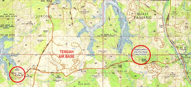
A 1965 map showing the areas known as Choa Chu Kang and Chua Chu Kang. (Click for full size details)

(Corrections made: In my original article, I name Chua Heok Nghee as the Kanchu of Chua Chu Kang. It has now been established that Chua Heok Nghee was the brother of the actual kangchu Chua Chin Huat. Chua Chu Kang settlement was developed in the 1840s by Chua Chin Huat and Goh Ah Piao who is Goh Tong Liang's grandfather.)
Goh Ah Piao later became the kangchu of Who Heng Kang, just south of Chua Chu Kang across the main trunk road. This area where his homestead farm started was later known as Lam San.

HOW TENGAH GOT ITS NAME !

In doing my research into the origins of the chu kangs of Singapore in the mid 19th century, I came across some very interesting information as well.
Yio Chu Kang was established by a kangchu name Eo Ah Chong. while Chan Chu Kang (today's Nee Soon/Yishun) was established by a kangchu name Chan Ah Lak.

But the most curious information was how Tengah probably got it name. 
Tengah means 'centre or middle' in the Malay language but its origin is not Malay!

In 1853, a surat sungai was issued to a certain Teng Ah Tong (aka Ting Ah Tong).
His chu kang was located at a then unnamed tributary of the Kranji River near Chua Chu Kang.
His concession became Teng Chu Kang and is recorded in a municipal survey of 1855 as Ten Ah Kang. Teng Ah Tong was colloquially known as Teng-Ah and eventually the  tributary river came to be called the Tingar River or Teng Ah River.
The area where he had his chu kang was acquired by the British military in the 1930s to build an airfield , which took the name of the location, Tengah.
The area thereafter became well known as Tengah because of the airfield.


Related links:
Bokokang- a village from our past