Wednesday, December 9, 2020

Malayan Guttas Vintage Photographs

Malayan Guttas Ltd  was a pioneer factory at Hillview, Bukit Timah. 
Many of you may never have heard of this company,  unless perhaps, you once lived nearby around Hillview or you might have known of it perusing through this blog of mine where I had previously written a few articles about it. (links below)

However, you will definitely recall its most famous product - the Wrigley Spearmint Chewing Gum.
The Wrigley Company of Chicago USA set up the factory in 1947 soon after the end of World War Two.

Following the end of war, the British Government offered extremely good incentives for foreign companies to invest in the colonies to revive the war-torn countries' economies. One major incentive was that their manufactured goods would be entirely tax-free if it was manufactured, distributed and sold in any British Commonwealth nation.

As a result, Malayan Guttas became the biggest manufacturer and distributor of chewing gum in all the British Commonwealth out from its factory in Singapore.
The other major incentive for Malayan Guttas was that its principal ingredient for making chewing gum could only be found in the Malay Peninsula, i.e. the then Malaya, Borneo and Indonesia. This was the resin Gutta Percha.


Gutta Percha resin is the inedible bit that gum chewers spat out and made a mess of the sidewalks!
Gutta Percha came from the endemic Sapodilla tree, of which the Chiku fruit tree was one species.
However, extracting the gutta percha resin was primitive even in those days. It had an unsustainable and destructive process in its extraction. They had to chop the entire tree down to bits and boil the wood to extract the resin. 
By the 1960s, due to the scarcity of the Sapodilla trees, they switched to the resin of the Jelutong tree. So Malayan Guttas became the biggest source of Jelutong resin and the centre for worldwide distribution.

Ironically, chewing gum was banned in Singapore in 1992 but by a strange twist of fate, the entire region of Hillview where the factory sat was then re-designated into a 'residential development zone'. The Wrigley Company sold the land to a private developer for a fortune in the late 1990s. The land was developed into the now Hillington Condominium complex.


The newly built Malayan Guttas factory in 1948.


Recently, I was very fortunate to receive a package of old photos from Switzerland.
It came from Pierre-Yves Bünzli, son of Mr Bünzli who was the General Manager in the late 50s to the early 60s.
In those days, the GM was numero uno. He oversaw the entire operations and personally lead many expeditions to Borneo to source for Jelutong resin.

The cache of vintage pictures, of which I will release periodically in future articles, were of the factory operations and of the staff.  Many of the staff were from the old Princess Elizabeth Estate and if you do recognise anyone of them in the photos, please comment below.


The cache of vintage photos I received.


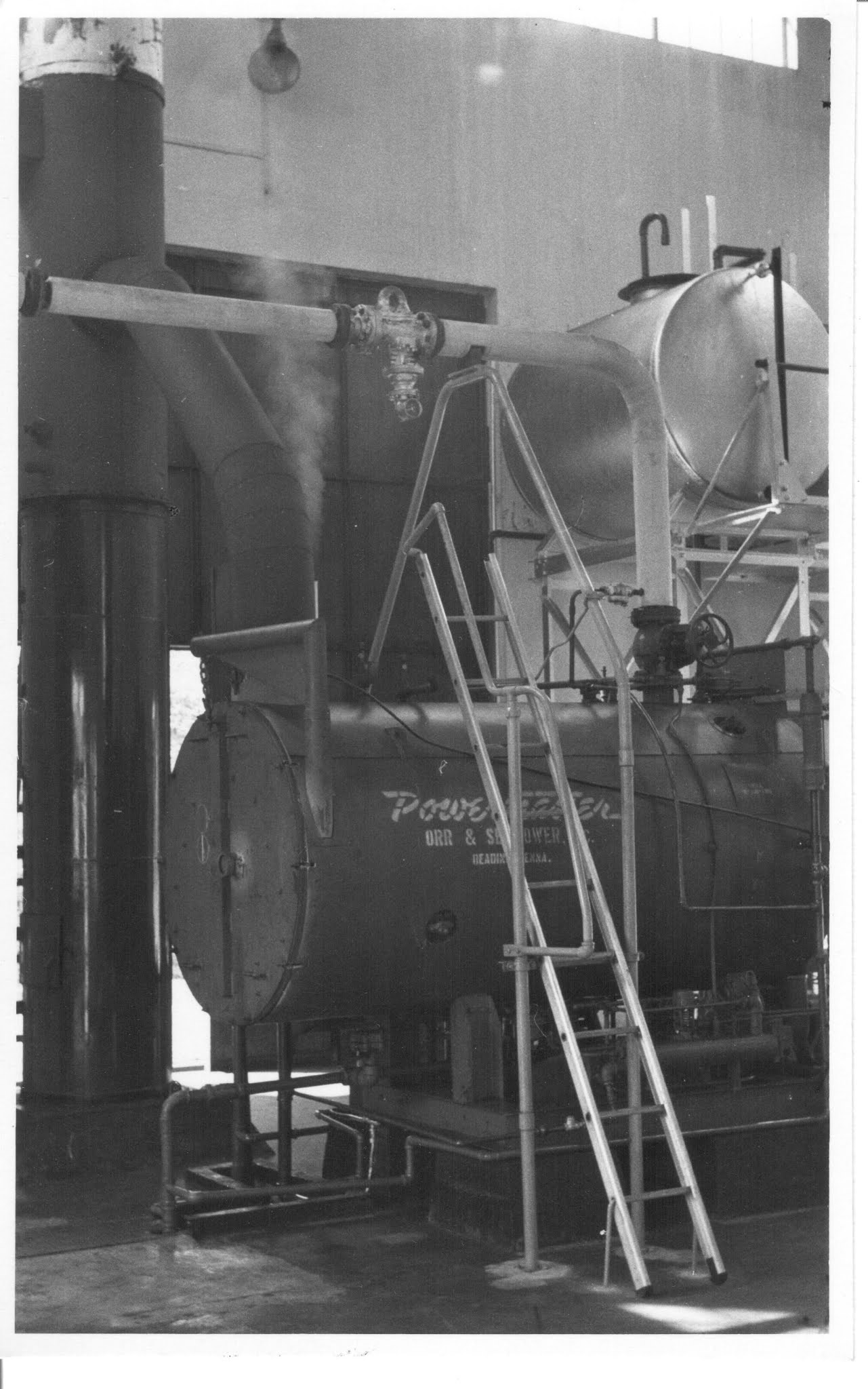
The machinery used in the resin extraction


The boilers used for resin extraction


Crates of resin extract stored at the back


Staff Group Photo c.1962


Staff function at the factory grounds.


Sunday, December 6, 2020

Dairy Farm @Bukit Timah in 1963

Going through the archives, I found an amazing old black & White photo that many people might have dismissed because it was improperly labelled. It had been labelled as 'Indian milk cows. Malaya 1963'.

However, when I took a closer look at it, I could straight away identify it as the old Cold Storage Dairy Farm at Upper Bukit Timah, where today the Dairy Farm Nature Park is located.

Here is the original photo I found.


Dairy Farm @ Upper Bukit Timah in 1963.

The clues to this picture lie at the top right hand corner.  
The main building is the cow milking shed that is today the Wallace Education Centre. 
If you follow the line left of this building, you will come to the uphill slope that leads to the Dairy Farm General Manager's house at the top which still exist today and which has been converted into a visitor centre. The last General Manager was Mr Phillip Fielding and the house is often referred to as "Fielding's House".

The long building in the picture in front of today's "Wallace building" was the cow shed where the cows were washed and inspected before being sent to the milk shed. Only the concrete foundation remnants of this building are left today, in the field in front of the Wallace Education Centre building.

Running right across the photo in the valley between the cows and the buildings is the location of the water pipeline that carries the raw water that Singapore buys from Johor state.

Today, this entire area in this photo is covered by secondary forest with the Wallace Trail running through part of it.

Update: 7 Dec 2020
Following my above posting of the old Dairy Farm, I search my own collection and came out with this rarely seen picture of Dairy Farm, also taken around the 1960s.

This photo shows the pasture behind the building that is now the Wallace Education Centre (right of photo). Today we see a forest there with no access into the area. The open field at the foreground of the photo is where NParks had recently built a new teaching/training shed.


You can read more about the Dairy Farm in my blog here at the following links:-
Places around Princess Elizabeth Est - Dairy Farm (Jan 2012)
The mysterious house at Dairy Farm (June 2014)

Thursday, August 20, 2020

The Railway lines at Hillview

In my previous article that I posted in July regarding the Hillview factories along Upper Bukit Timah Road, a lot of interest was centred on the two railway lines that ran past Hillview. These were, firstly, the 1903 Singapore-Kranji Railway, and secondly, the 1932 KTM Railway that 'replaced' the 1903 railway line. I must clarify that even though I occasionally write about the railways, I am not a rail enthusiast, nor an expert on this subject, and my writings about them only relate to my blog articles here.

One of my contacts, a local railway expert, Trevor Sharot, had earlier re-discovered and confirmed the existence of a tunnel that was seen in old 1950 aerial photo maps. This tunnel is under the now 'Green Corridor' and is not clearly visible by any and all who trek along this conservation corridor. It is covered by shrubs and overgrowth. I have marked it out in this 1950 aerial photo. I will do a writeup on this tunnel in a future blog article.


The hidden tunnel under the old 1932 railway track.


Another old friend and railway enthusiast, Peter Chan, also got in touch with regards to the older 1903 Singapore-Kranji Railway. Peter's grandparents lived at the Chestnut area and had seen the building of the 1932 KTM railway that was to replace the 1903 Singapore-Kranji Railway.
More fortuitously, Peter's grandfather had the presence of mind to take photos of the construction in those days, and Peter shared one with me.


What is interesting about the black & white 1931 photo is that it shows the steel truss bridge being built across Upper Bukit Timah Road in 1931 for the new KTM Railway that would run to Tanjong Pagar. This now retired truss bridge is being conserved today as a heritage item along with the rail corridor.

What is of greater interest in this B&W photo (especially to rail enthusiasts) is that you can see behind the bridge, the level on the hillside where the older 1903 Singapore-Kranji Railway line ran down from the hill (where Ford Motors would later be built). It was on a higher level above Bukit Timah Road.

With Peter's permission, I enhanced the old B&W photo and found that I could then make out the old telegraph poles that ran alongside the 1903 Kranji railway tracks! The old telegraph poles were significant in determining the layout and alignment of the 1903 tracks as seen in my previous posted article. (The red line).
In the old days, telegraph poles were built parallel alongside the railway lines.

 Note the 1903 telegraph wires up on the bridge level (right of pic).
There also appears to be overhead electrical cables alongside Bukit Timah Road as well. These can be seen beneath and beyond the bridge.


Peter then sent me more photos he had!
These were the actual remnants of the telegraph poles which he found and had kept!


Parts of the 1903 telegraph poles.

Insulator
The telegraph wire insulator.
(Peter's souvenir from 1903)


Monday, July 20, 2020

Hillview as seen from Upper Bukit Timah 1957.

Source: National Archives of Singapore/British Royal Air Force Collection.
Thanks to Lai Chee Kien and Trevor Sharot for confirmation of the 1903 line location


Here is a picture that is worth a thousand words!
Colorised from an old RAF Sqn 81 aerial survey photo taken in 1957, this is the Hillview region at 9th milestone (14km), Upper Bukit Timah Road.

On the left are the factories of Hillview in 1957, starting with Hume Pipes Co Pty Ltd at bottom, Rheem Hume Co Ltd, Malayan Guttas Ltd, National Carbon and finally, the Hong Kong Rope Manufacturing Co. The Chartered Bank Hillview Branch is to the right of Hong Kong Rope Mfg Co.

Fuyong Estate is across Upper Bukit Timah Road and the KTM Railway truss bridge straddles the highway prominently at this point.

The red roofed buildings today house the Rail Mall shopping arcade and eateries. It was built in the early 1950s by philanthropist, Mr Lee Kong Chian, as low-cost workers quarters to house his employees who worked his rubber plantations in the area. I used to live at Fuyong Estate from the mid-60s till the mid-1980s. My old house was the 4th semi-detached unit up the hill behind 'Rail Mall' . The back of my old house faced the factories across the road and everyday I would see the KTM trains going by.
You can't miss the trains because at this point, just before the girder bridge at Hillview Road, they were required to 'WISEL', as the signal signboard indicated. Whistle to warn of an approaching train.

Among other things to note here was the railway sidings just to the left of the bridge. There were two sidings, off the main railway line, that were used exclusively by the Hume Pipes Co. These were used to load the manufactured pipes for conveyance up to Malaya then, where Hume Industries was a major supplier of concrete pipes for the country's development. 

The first railway line that ran through Hillview was the 1903 Singapore-Woodlands Railway (aka the Tank Road-Kranji Railway). I have sketched out the approximate line location where the 1903 railway ran through this part. (red line).  The other railway line that passed Hillview was the 1932 KTM railway line. The 1903 railway line became defunct, and eventually removed, when the 1932 KTM railway line started operations.

Initially built by the Federated Malay States Railways (FMSR). It was later incorporated by the governmental Malayan Railway Administration (MRA) and in 1962 became known as the Keratapi Tanah Melayu (KTM), the name which most of us associate the railway line with. 

It was the FMSR that built the black truss bridge over Upper Bukit Timah Road, which has now been declared a heritage conservation structure.
The former KTM railway line was closed and subsequently removed in 2011 and the old rail bed is now preserved as part of the Green Rail Corridor conservation project.

Related reading.
The Hillview Road Girder Bridge
Rail Mall

Sunday, July 19, 2020

Factories around P.E.Estate #13 - Malayan Textile Mill

       After all these years describing the various former companies and factories located at Hillview, you would think that Malayan Textile Mill would be on top of the list. It being one of the original four factories set up back in 1953. Yet until now, it was left out because I really did not have much information on this entity! It'll also probably be the last factory to be covered in this series on the factories around Princess Elizabeth Estate.


Fronting Hillview Avenue with its distinctive serrated roof, the Malayan Textile Mill was built on a large 3000ha piece of freehold land. In the 1950s, textile production in East Asia was becoming very popular due to the low cost and producers in Hong Kong, Taiwan and Japan were getting renown for their quality textiles.

Malayan Textile Mill was set up to spin yarn.  Yarn being the raw material used by other textile mills to produce finished fabrics, textiles, knittings and other types of cloth.

The Malayan Textile Mill machinery spinning yarn on spools.
In the tumultuous 1960s, the factory was involved frequently with workers wildcat industrial action and strikes. This was a time of growing awareness of workers rights, mainly over the low wages and working conditions.

By the 1970s, there were up to 25 textile mills in Singapore but most were inefficient and unprofitable. It was an industry where local expertise and skilled workers were in very short supply. Experienced textile workers tended to migrate to other factories with better pay. This eventually led to a detrimental situation for the entire textile industry in Singapore, and to the eventual closure of most mills.

The Malayan Textile Mill was bought over by another company and renamed as the International Spinning Mill. It lasted well into the early 2000s when it was sold to real estate developers to built condominiums on the site.

Today, Hillview Green Condominium sits on the old factory site along Hillview Avenue.


Related links:-
#1 Factories that were located at Hillview
#2 Cycle & Carriage
#3 Ford Motor
#4 Amoy Canning
#5 Malayan Guttas
#6 Castrol
#7 Union Carbide
#8 Kiwi Polish
#9 Magnolia Dairies
#10 Hume Industries
#11 Hong Kong Rope Manufacturing Co
#12 Central Oil Refinery
#The Hillview Industrial Estate

Wednesday, July 15, 2020

Factories around P.E.E. #12 - Central Oil Refinery

The factory along Hillview Avenue.
Green Bus service No. 5 about to turn towards (Princess) Elizabeth Drive.
The Central Oil Refinery was built in 1951. It was one of the four original enterprises that were set up by the Colonial Development Corporation at Hillview Avenue to spearhead what was supposed to be the Colonial Industrial Estate at Bukit Timah.

Built by local entrepreneur, Mr Lim Seow Peng, with investors from Hong Kong, it produced cooking oil, margarine and soaps derived from palm oil.
In 1964, it achieved a local first breakthrough by refining a cholesterol-free poly-unsaturated oil from groundnuts and marketed as a healthy oil, free from saturated fats.
Flag Brand Groundnut oil advertisement from the Central Oil Refinery.
(extract ©NLB microfile 12158)
When the new Popular Estate was developed in the area behind the factory in the late 1960s, the factory premises was separated from the new estate by a narrow road, Jalan Batu Nilam. 
The close proximity resulted in a torrent of complaints from the new house owners about the air pollution and heavy oil smells emitted by the factory.

The building of Popular Estate behind the refinery in 1963.

Despite much intervention and mediation by the authorities, the problem of the persistent oil smell were never fully resolved. Relief for residents only came when Hillview was re-designated from an industrial zone to a residential zone. The factory land was sold to a real-estate developer, City Development Ltd.

Today, the Chantilly Rise condominium is located where once the Oil Refinery stood along Hillview Avenue.
Related links:-
#1 Factories that were located at Hillview
#2 Cycle & Carriage
#3 Ford Motor
#4 Amoy Canning
#5 Malayan Guttas
#6 Castrol
#7 Union Carbide
#8 Kiwi Polish
#9 Magnolia Dairies
#10 Hume Industries
#11 Hong Kong Rope Manufacturing Co
The Hillview Industrial Estate

Monday, July 13, 2020

1924 map of Hillview area.

Recently, I was chatting with a friend about the old Singapore-Woodlands Railway, aka the Tank Road-Kranji Railway of 1903. This railway ran past Hillview along Upper Bukit Timah Road. I mentioned I had an old map which showed the railway alignment and went to search my archive. I have not used this map previously in my blog because I couldn't link much to what I could say about Princess Elizabeth Estate, it being drawn 30 years before Hillview and PEE even existed.

Here is an extract of the 1924 map. I have superimposed the main roads of today's Hillview into the map for you to reference in reading the map.

Click on the picture for a detailed view.

On seeing this old map and scrutinising it closely this time, I came to a realisation that I was mistaken all this while about the old 1903 rail alignment. I had always assumed that the line ran alongside Upper Bukit Timah Road from Mendoza Village, up to where the Ford factory would be, and then followed the road downhill and northwards towards Bukit Panjang. 

From the map, I saw that from where Ford would be, it continued up on a high embankment (in fact following what is today Hume Ave!) before coming down towards the Chartered bank /MRT Station level and then continuing on northwards.
It did not run alongside Upper Bukit Timah Road from where Ford would be to the Chartered Bank! You live and you learn new things everyday. I stand corrected.

This is the junction of Hume Ave and Upp Bt Timah Road, just after where the old Ford factory was.

The 1903 Singapore Kranji Railway travelled up on the road on the left (now Hume Ave). Upp Bt Timah Road (right) went downhill from here towards Bukit Panjang. I had mistakenly assumed the old 1903 Railway followed the downhill road.
The 1932 KTM Railway was on a different alignment parallel to Upp Bt Timah Road here, beyond the trees to the right. The 1932 KTM Railway would cross Upp Bt Timah Road at the black Truss bridge near today's Rail Mall. (Jalan Asas)Pic from Google Earth,

In line with the recent articles I wrote about the history of Hillview, and looking closely at the map, you can see that the entire area was marked with 'rubber trees' or rubber plantations (green map symbols). So this confirmed that the entire Hillview area was a rubber growing region in 1924.

Also marked in the area around the peak of Bukit Gombak (top left) you can see markings of 'pineapple' symbols.  This would also confirm that the Hillview region went through the agricultural stages from gambier to pineapple and lastly to rubber.

Lastly, this map also vindicates what I always debunked as a myth when people ascribe the name Bukit Batok to the 'coughing' of the dynamite blasting of the granite quarry giving rise to the name of the hill as Bukit Batok - "Coughing Hill".  (Map lower centre)
The quarry at Bukit Batok, called the Poh Kim Quarry, operated only after World War 2 ended in 1945. Yet this 1924 map already had the name Bukit Batok pinned to it. So the coughing hill theory is totally debunked.

Something, you might also want to note is that in this 1924 map, Upper Bukit Timah Road and Woodlands Road were actually named as Kranji Road.

This is a superimposed Google map over the 1924 which I used to get the road alignments.


Note: The 1903 Tank Road-Kranji Railway is a different rail line to that of the 1932 KTM (Keretaapi Tanah Melayu) Railways that ran almost in the same alignment from the black railway bridge at Rail Mall to Woodlands. 

Sunday, March 8, 2020

One Million Views

Today, 8 March 2020, marks a milestone for my Princess Elizabeth Estate blog here.
Total viewership to this blog has passed the 1,000,000 views mark.

I started blogging back in 2007 when a colleague suggested I write about my travels.
I found blogging quite easy and quite fun but the enthusiasm was short lived.
I realised that my travel blog had no focus. It was all rambling and was going all over the place (he he, pun intended)

So in 2011, I decided to focus on one topic and that was to recall the memories about the place where I grew up, my kampong Princess Elizabeth Estate.
This was the place that was most dear to me, my growing up years, my neighbourhood friends, classmates, my schooldays. As a baby boomer, I watched my parents struggled through this period. The period of self-sacrifice and nation building.

So I intended that some record of my early life there would somehow remain for posterity.
The blog has expanded to over 190 articles to date. I hope to continue to write more about the place and I hope my readers will continue to contribute stories and photos to keep our collective memories alive.

A big Thank You to all my viewers and readers for visiting over the past 9 years.

I write so that the story that lives with me, will live with you as well. When a story is told, it's not forgotten; it becomes something else..the memories of who we were, the hope of what we can become.
(Sarah's key by Tatiana de Rosnay)


Friday, February 21, 2020

Lee Kuan Yew's Walkabout at Princess Elizabeth Estate 1963

Nineteen Sixty-three was a tumultuous year both for me and for Singapore.
For me, I was still in primary school learning my ABCs and Times Table. Yes, in my time, children hardly ever attended kindergarten then. We started 'learning' in primary school. I was barely cognisant of what was happening outside of my school life!

For Singapore, it was a politically heady time. Singapore had declared itself independent from the United Kingdom, it appointed its own Head of State (Yang di-Pertuan Negara) and had its own Prime Minister. In de facto, Singapore freed herself from British colonisation that year.
Ahead was a planned merger with some states of Malaya and Borneo, that was being opposed both locally and internationally!

In the political turmoil after the 1959 election, Prime Minister Mr Lee Kuan Yew won a 1962 referendum for merger with the Federated States of Malaya and some North Borneo states to form the new Malaysia.  To quell opposing views about the forth-coming merger, Mr Lee visited all 51 constituencies in Singapore in 1963 to explain their rationale for this merger.

On 5th May 1963, he visited Princess Elizabeth Estate as part of his tour of Bukit Timah Constituency.

Keep in mind that back in 1963, there were no resident's committees, no citizen consultative branches, no grassroots organisations, etc. Estates, kampongs, villages and settlements were all run by whoever appeared to be the leader and accepted by the community as head. All were volunteers.

At Princess Elizabeth Estate, the 'management' of the estate was taken up by the community centre management committee (CCMC), who sort of oversaw more than just what took place within the community centre. They also played the role of  'estate managers' when requested and acted as liaisons with officialdom on behalf of residents in the estate.
The community centre was not as yet under the purview of the People's Association.
Then they were all volunteer residents from the estate who stepped forward to help their own community.

I recently came across archived photos of Mr Lee Kuan Yew's visit to Princess Elizabeth Estate in 1963, during which he also laid the foundation stone for the new People's Association Community Centre building at Prince Charles Rise. These photos are from the archives of the National Archives Singapore (NAS) and all copyright belong to them. I do not own any of the attached photos.

If you lived at Princess Elizabeth Estate then and can recognise anyone from these pictures, please do drop me a comment so that we can all enjoy these old memories the better.

Mr Lee Kuan Yew arrives at Princess Elizabeth Estate in his Landrover along Princess Elizabeth Drive.
Children from Princess Elizabeth Estate School lined the road as guard of honour to welcome him.
PEE School is at the far background and the row of houses at the left were the new
Popular Estate terraced houses that were not yet occupied.
I can still vividly recall this event and more so because we schoolchildren were each given a cupcake and a bottle of
Green Spot orange drink when we were re-assembled back in school after his arrival.

Mr Lee being garland by Dr Raja at the car park that was also the Green Bus Terminal.
Can anyone remember that Estate signboard at the bus terminal?
Dr Raja, the only physician in our estate was the CCMC Chairman at the time.
The walkabout began with a tour of the estate and meeting residents.
They were walking across the small field in front of Blk 22. In the background is the rear of Blk 21 where I lived.
Dr Raja leads the entourage in front of LKY.
Mr Lee Teck Hup is at the far right.
Passing Blk 20 Princess Anne Hill, the longest block of flats in the estate.
Coming down (Princess) Elizabeth Drive from Blk 24.
Notice how narrow Elizabeth Drive was? With cars parking along the edge, another car can pass only in one direction.
If cars came head on, someone had to reverse and back away to allow the other to pass.
The same procession from an obverse view. LKY waving to residents at Blk 23.
The man beside Dr Raja in front I can only remember as Tony Chua's father.
Entourage heading down Princess Anne Hill to Prince Charles Rise to the new
PA Community Centre building site for LKY to lay the foundation stone.
Man on the left of LKY was my father, Tann Yean, who was also on the CCMC,
Dr Raja on the right of LKY.
LKY speaking to residents on the construction site of the new PA community centre
in front of Blk 17, Prince Charles Rise.
He spoke about the upcoming Merger with Malaya to form Malaysia.

The new PA Community Centre was built over the old badminton courts and the grove of Mangosteen trees.
Notice the ramshackle huts and zinc roofs on the far left? That was the old 'market' stalls.

Mr Lee laying the foundation stone for the new Community Centre.